
|

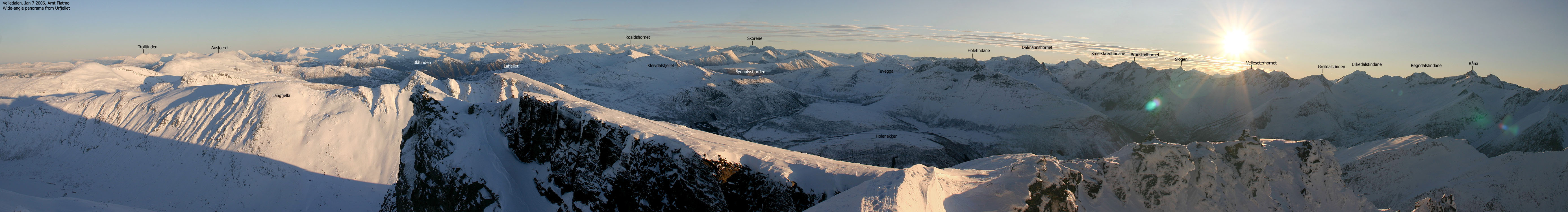
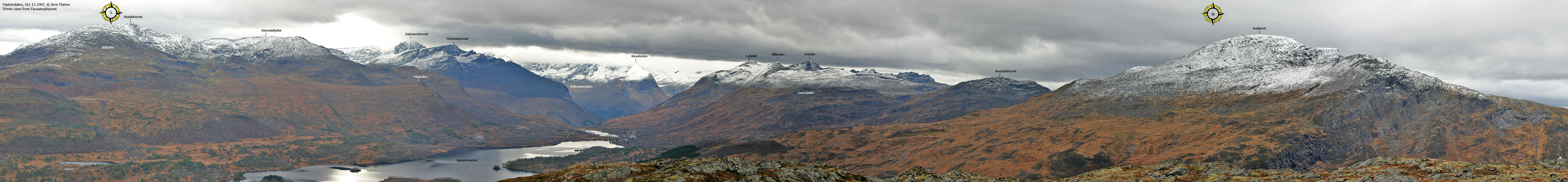
Langfjella is the name of a long mountain ridge that rise gently from Sykkylven and fall steep into Velledalen. The southernmost tops on this ridge are Blåtinden (Blue Peak) and Lafjellet (the name comes from the place La in Velledalen). Both Blåtinden and Lafjellet can be hiked without difficulties, and are also popular as skiing tops when the snow is safe.
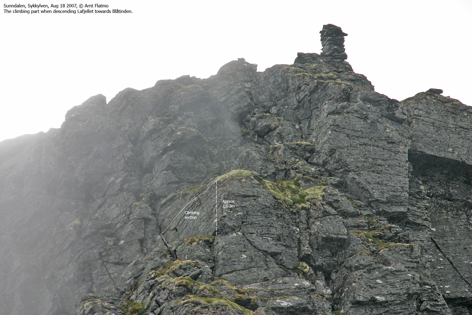
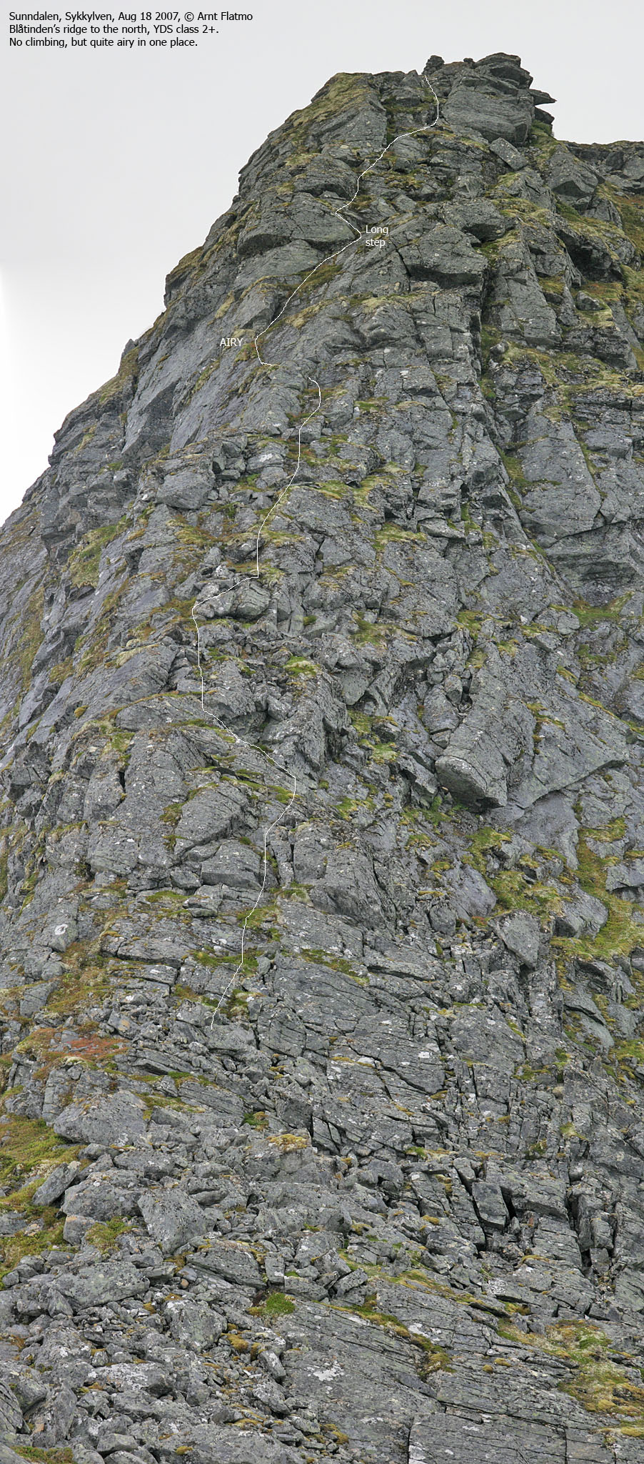
Both tops are normally visited from Sunndalen. Lafjellet is easily reached on its east ridge, and Blåtinden is easily reached on its south ridge. In order to hike from Lafjellet to Blåtinden, you'll have to descend a steep section (30m) where one point requires some easy climbing. If you want to descend Blåtinden to the north, you'll descend another steep section (60-70m) which doesn't require climbing, but is quite airy. This web page will describe a traverse across Lafjellet and Blåtinden and is targeted for those who are used to handle steep and airy terrain. But the route description will also help other hikers to reach both tops without difficulties. Note that Lafjellet can also be reached from the southwest. See the Urfjellet page for information about the Brunstad trailhead.


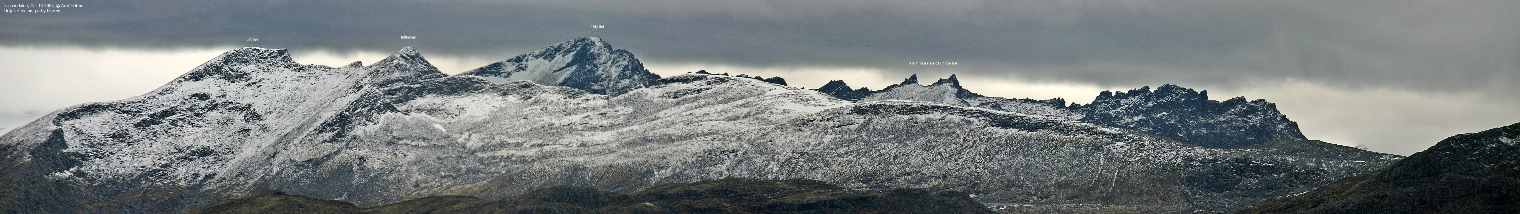
Blåtinden (Norge 1:50,000: 1165m, Økonomisk Kartverk: Highest contour is 1160m, UTM 32 V 381515 6913142) has a primary factor of 323m, towards the higher parent mountain Urfjellet (1267m). The saddle (approx. UTM 32 V 380978 6912472) is found between Lafjellet and Urfjellet. Ref. Økonomisk Kartverk (5m contours), the saddle height defined as a fixed point - 842m.
Lafjellet (Norge 1:50,000: 1161m, Økonomisk Kartverk: 1160,53m, UTM 32 V 381521 6912741) has a primary factor of 51m, towards the higher parent mountain Blåtinden (1165m). The saddle (approx. UTM 32 V 381491 6912936) is found between Lafjellet and Blåtinden. Ref. Norge 1:50,000 (5m contours), the saddle height is within the range 1100-1120m, interpolated to 1110m.
Point 1118m on Langfjella (Norge 1:50,000: 1118m, Økonomisk Kartverk: 1118m, UTM 32 V 381322 6913748) has a primary factor of 48m, towards the higher parent mountain Blåtinden (1165m). The saddle (approx. UTM 32 V 381491 6912936) is found between Point 1118m and Blåtinden. Ref. Norge 1:50,000 (5m contours), the saddle height is within the range 1060-1080m, interpolated to 1070m.
Notes:
The above information is based on the available maps, except for the summit coordinates which are from a GPS. And it might be correct. However: The GPS reading on Lafjellet suggest that Lafjellet and Blåtinden are equally high. The GPS might not have been accurate, and you will find many pictures that suggest that Blåtinden is higher.
Lafjellet has two high points UTM 32 V 381521 6912741 (the trigonometric point) and UTM 32 V 381483 6912798 (the cairn) Both these points were measured to 1165m on the ground, as average between 5 and 10 minutes. On Blåtinden, the GPS measured 1166m on top of the cairn (approx. 1m high). The averaging time and error margin (1.8m) were the same on both tops. On point 1118m, the GPS reported 1119m on top of the cairn (approx. 1m high) over 5 minutes. It was impossibe to tell from either top, if the other was higher.
Lafjellet's cairn point, equally high as (or higher) the trig. point is found on the 1140m contour on the GPS map. The Lafjellet - Blåtinden saddle point (approx. UTM 32 V 381479 6912866) was found on the 1120m contour, approx. 70m south of the map's saddle point (where the 1120m contours meet). Blåtinden summit is located just outside the 1160m contour on the map, and the cairn on point 1118m was found 44m north of where the GPS map says it should be.
It shall not be claimed that the GPS information provided in this section is 100% accurate, but it might encourage you to do some research on your own, providing you have any tools for measurements. THIS PICTURE suggests that Blåtinden is slightly higher than Lafjellet, and that the trig. point on Lafjellet is higher than the cairn point.


Google's interactive map. You can zoom, pan and click on the markers.
Notes: Class ratings are in reference to YDS. Click here for more information.
The trails described below are not necessarily the *easiest* trails to this mountain.
|
Sunndalen (Fjellsetra side) - Lafjellet - Blåtinden roundtrip (summer/autumn)
|
|
Access
(all distances are approx. distances)
From Ålesund, follow highway E39 towards Bergen, and then highway RV60 (Stranda) to the Magerholm - Ørsneset ferry. This ferry runs quite often; every 20 minutes in the busy hours of the day. From Ørsneset, follow RV60 (Stranda) approx. 22,4Km and turn left towards "Fausa/Fjellsætra". Drive 900m and find parking near Sunndalselva.


The route
To Lafjellet (YDS Class 2):
Hike off-trail along the Sunndalselva river. Pick a route (either side of the river) where you can follow boggy meadows. The bush is not a great alternative. If you stay on the north side of the river, follow the river all the way to 640m elevation, before you turn southwest towards Lafjellet's east ridge. From distance, it may seem difficult to get onto this ridge, but it isn't. Just stay close to the edge on the north side of the ridge, and you'll be fine. You'll reach the top of Lafjellet without the use of your hands.
It isn't easy to tell which is the higher point - the trigonometric point (you'll know that there used to be one when you trip over the wire) or where the cairn is, 70m to the north/northwest.
To Blåtinden (YDS Class 3):
The descent route from Lafjellet is obvious; there is only one. The steep section (approx. 30 vertical meters) is overall YDS Class 2+; you'll descend with caution, but without any difficulties. There is however a drop of 2,5-3 meters where you'll easily climb down using a ledge with good handholds. But you'll need to climb, which makes the route YDS Class 3. There is no "direct" exposure on this point. If you slip, you'll most likely end up on the ridge below the ledge.
The hike up to the Blåtinden cairn is easy YDS Class 2. If you look down to your right, just before reaching Blåtinden, you'll see the long hill with mixed grass and boulder that is the normal route to this top.
To Point 1118m (YDS Class 2+):
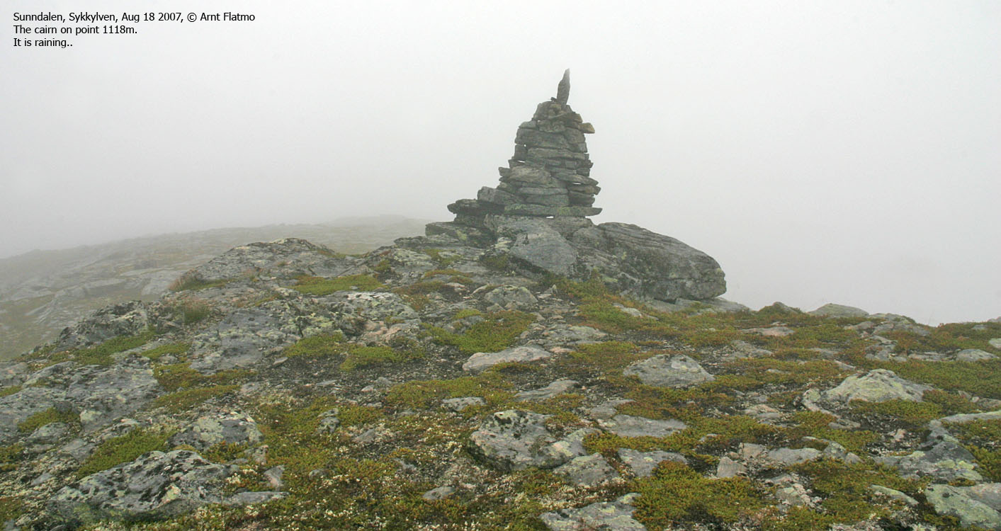
On your way down Blåtinden, you'll notice a gully to your left. Some choose to descend this way, but there is no need to. Descend the main ridge which doesn't require any climbing. There is one very exposed point on this route. A fall will end in disaster, and some people would prefer to be secured by a rope. However, the point isn't difficult. Just lower you center of gravity and move carefully. The rest of the route up to the cairn on point 1118m is easy.
Descent:
From point 1118m, proceed 250m to the north before you head southeast into Sunndalen. The terrain is mixed rock and grass. As you approach the valley, gradually adjust your direction towards your ascent route.


No Javascript:
 westcoastpeaks.com
Other Møre & Romsdal mountains
Other Norwegian mountains
westcoastpeaks.com
Other Møre & Romsdal mountains
Other Norwegian mountains

