
|

Kvannto (right) seen from Tverrfjellet(No Javascript) |
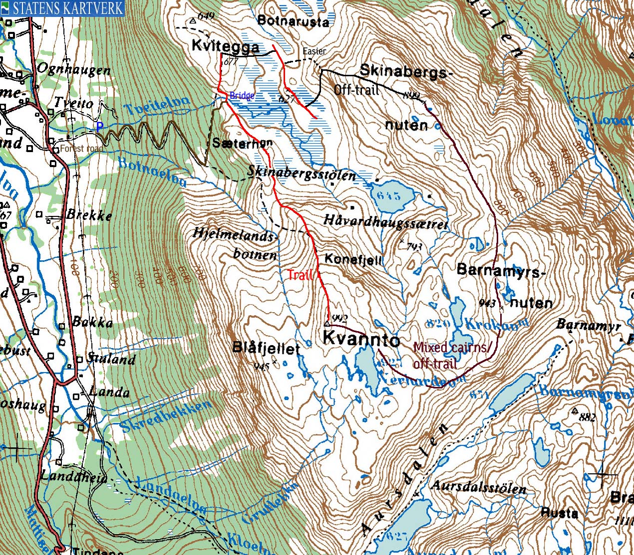
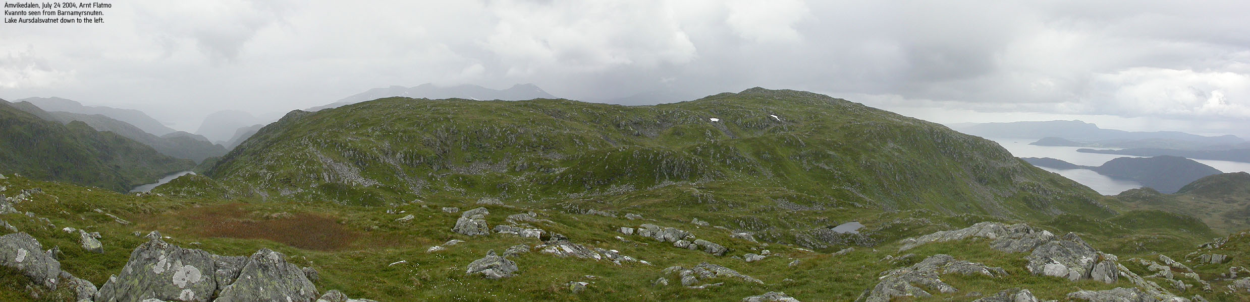
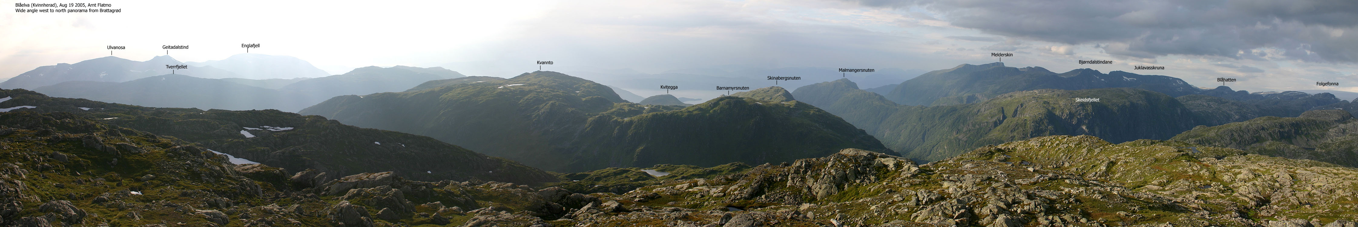
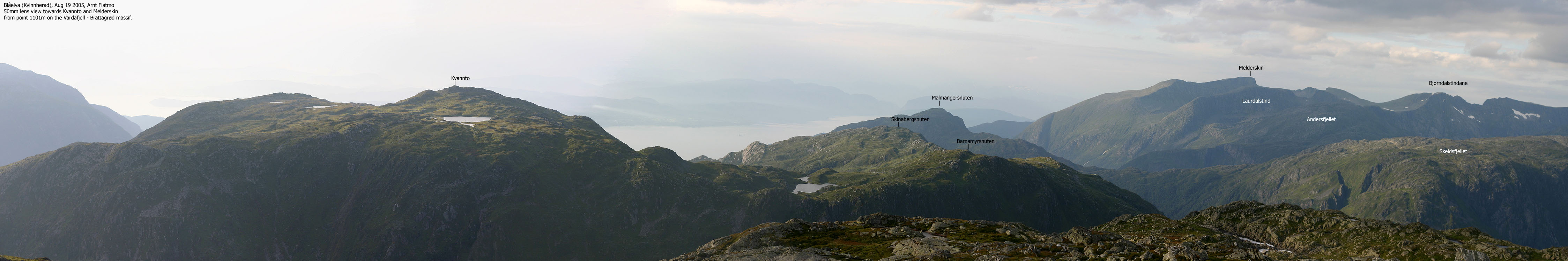
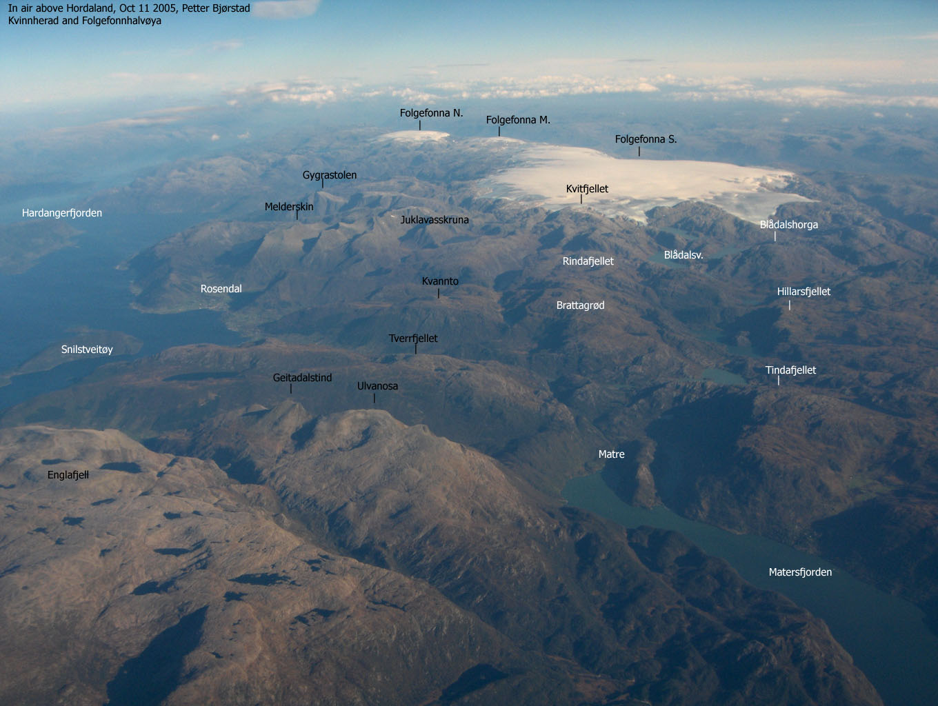
Kvannto is locate above Åmvikedalen, on the east side. Together with its neighbour tops Barnamyrsnuten and Skinabergsnuten, Kvannto form a horseshoe around Skinabergsølen and Håvardhaugsætret. Kvannto is very accesible for the public thanks to a forest road that runs up to 590m elev. and a "T" marked trail straight to the top. Visible, but not marked paths takes you across Barnamyrsnuten and Skinabergsnuten on the high ridge.
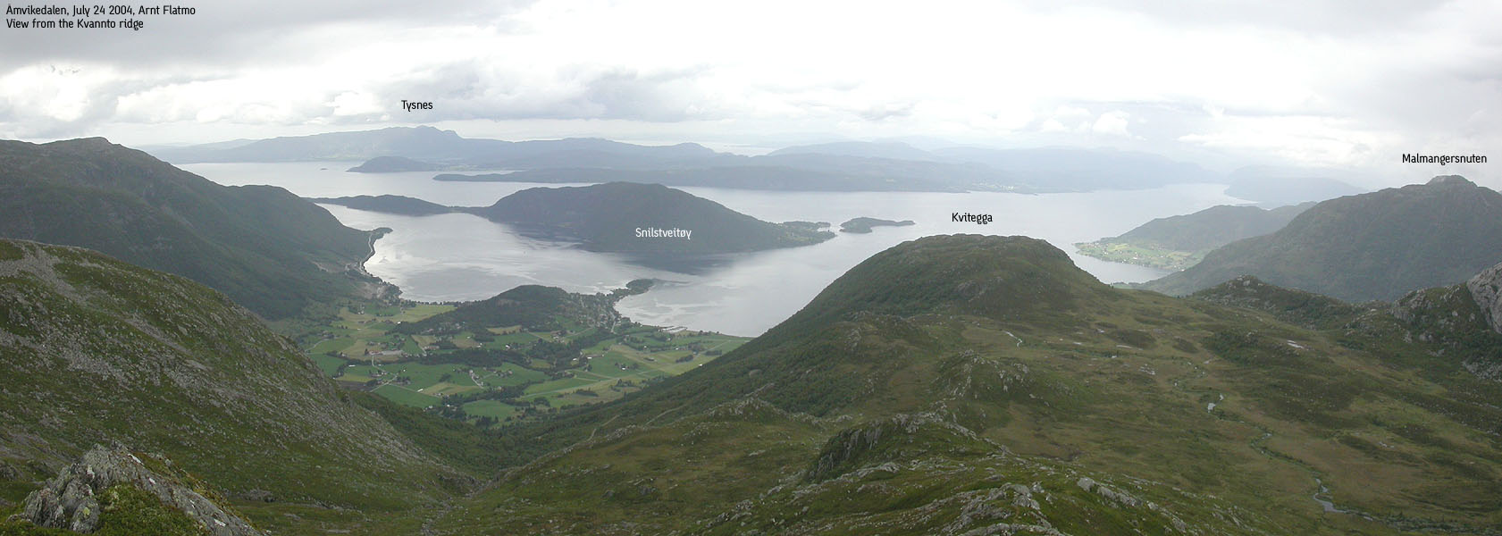
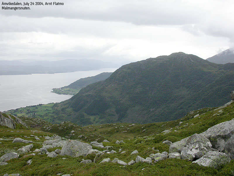
Kvannto is located between the Rosendal "alps" and the Ulvanosa massif, and you have view towards all these mountains. In addition, the mountains on the west side of Hardangerfjorden, including Fusa, Kvamskogen and Øystese mountains.
This page will describe a round-trip hike across these three summits, including Kvitegga. My original plan was to descend Barnamyrsnuten's east ridge and down to lake Barnamyrsvatnet. Then follow a trail back down to Åmvikedalen. I decided to skip this route as I will get familiar with that terrain when I visit Brattagrød. For those who only wants to visit Kvannto and Barnamyrsnuten, this may be a good option. I would also assume that Kvannto's south ridge is quite doable, which provides a significant shortcut to the route mentioned above. That way, you don't have to go all the way to Barnamyrsnuten and still get a round-trip. I am convinced that there are other good options for a round-trip (such as across Kvitegga), but these trails are not shown on the map.
Primary factor:
Kvannto has a primary factor of 262m towards the higher Rindafjellet. The saddle is found east of Barnamyrsnuten. The M711 map states that the 740m contours define the saddle. The saddle height has been interpolated to 730m.
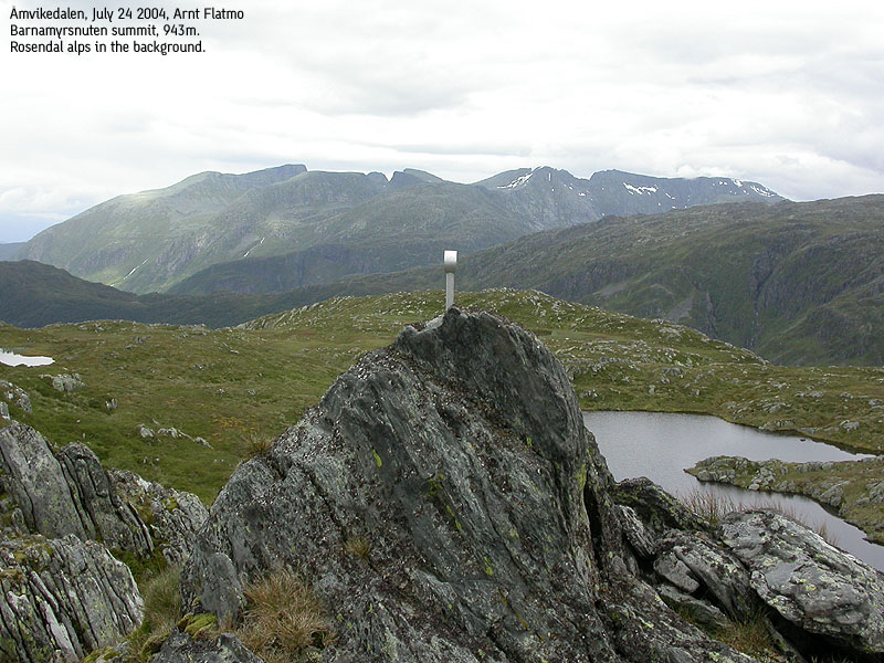
Barnamyrsnuten has a primary factor of 93m towards the higher Kvannto. The saddle is found east of Barnamyrsnuten. The M711 map states that the 860m contours define the saddle. The saddle height has been interpolated to 850m. Mountains with a primary factor < 100m is not considered independent mountains on this web-site, but by 93m, Barnamyrsnuten is definitely a prominent top!
Skinabergsnuten has a primary factor of 69m towards the higher Barnamyrsnuten. The saddle is found east of Barnamyrsnuten. The M711 map states that the 840m contours define the saddle. The saddle height has been interpolated to 830m. Based on my GPS, I am convinced that Skinabergsnuten is a bit higher, and would suggest 903m.
Kvitegga has a primary factor of 79m towards the higher Skinabergsnuten. The saddle is found between the two mountains. Økonomisk Kartverk (5m contours) states that the 600m contours define the saddle. The saddle height has been interpolated to 598m. This is based on a height of 677m. The 5m contour map shows that the high point is at least 675m. As such, the height is interpolated to 677m. The 649m trig. point is definitely not the high point.
Notes: Class ratings are in reference to YDS. Click here for more information.
The trails described below are not necessarily the *easiest* trails to this mountain.
|
Åmvikedalen - all summits round-trip (summer)
|
|
From Bergen, follow highway E16 towards Oslo. At the E16/highway 7 junction at Trengereid (roundabout), exit right onto highway 7. Drive down to Samnangerfjorden, Pass Bjørkheim, two tunnels and turn right onto highway 48 (Rosendal/Tysse/Mundheim).
Drive to Mundheim by Hardangerfjorden, approx. 41,5Km from the highway 48 junction. Turn right onto highway 49 towards Gjermundshamn/Rosendal, and follow this road for approx. 12,9Km to the Gjermundshavn ferry. Take the Gjermundshavn - Løfallstrand ferry. The ticket for passenger cars (1 person) was per July 2004 NOK 68,-.
From Løfallstrand, turn right towards Rosendal. Drive through Rosendal and after approx. 8,3Km (from where you entered the road by Løfallstrand) turn left towards "Matre/Åmvikedal". Follow this road for approx. 1,8Km and locate a gravel road that runs up to a farm. You will see a "Kvannto/Kvitegga" trailsign a bit up the road. Turn in here and drive approx. 400m. You will see parking for two cars next to an old building by the river.
As far as I understand, people may drive all the way up to road end at 590m. The road quality is not all bad, but the road is a forest road more than a gravel road. I recommend you park below and walk up the forest road.
Kvannto
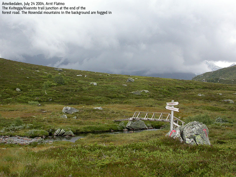
Follow the forest road to road end. Here you will see a "Kvitegga/Kvannto" trail sign. The trail to Kvitegga (up to your left) runs over a bridge to your left. The trail to Kvannto is "T" marked all the way and runs up the Kvannto north ridge. The route is quite obvious when seen from the end of the forest road. This is a class 1 trail. The Kvannto summit is marked by a proper trail. There is also a trail register in a metal box.
Barnamyrsnuten
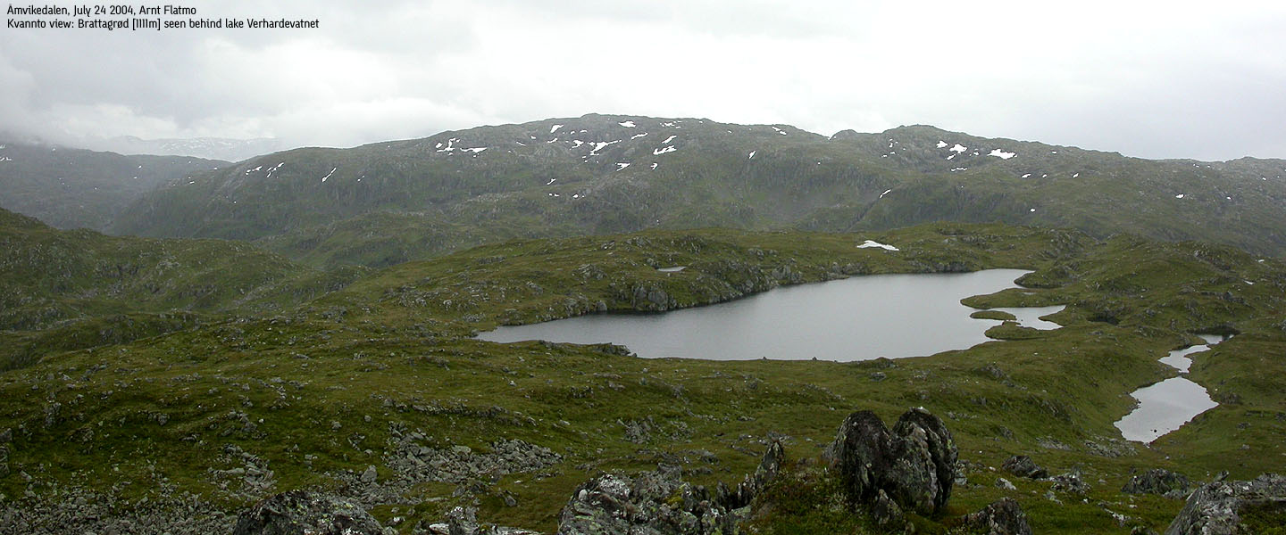
You should more or less be able to follow a narrow path that runs on the high ridge between the two mountains. Pass north of lake Verhardevatnet, and if you lose sight of the path, don't descend into the saddle too early. Stick on the high route even if it cost you a few additional vertical meters. There is no cairn on the summit of Barnamyrsnuten, only a bolt marking the high point.
Skinabergsnuten
In general, follow the high route between the two mountains. The path will not always do this, so you will have to decide where you want to go. If you stay on the right hand side of the high route, you will have some great views down to lakes Barnamyrsvatnet and Aursdalsvatnet. Skinabergsnuten has two summit humps, seemingly of equal height until you are on top of the northernmost. Then you see the southernmost hump is the highest. A few rocks marks the summit. The high route from Kvannto across Barnamyrsnuten to Skinabergsnuten is class 1.
Kvitegga
The best thing would really be to head back down to the Barnamyrsnuten - Skinabergsnuten saddle and hike down to lake 645m near Skinabergstølen. If you want a more direct route, hike northwest from Skinabergsnuten. You will reach cliffs near 700m elevation. If you turn left (south), you will through some routefinding make it down to the meadows. Be very careful here - the terrain is mixed boulder and grassy turfs. Feet get easily stuck in nasty holes here. Alternatively, turn right (north) and continue down the ridge. There is some slick rock here, but enough grassy slopes inbetween to make it safely down. Once down on the meadow, head straight across to Kvitegga. Kvitegga also has two humps of similar height. The southernmost is the highest, and a strange looking cairn marks the summit. Follow a "T" trail back down to the forest road.
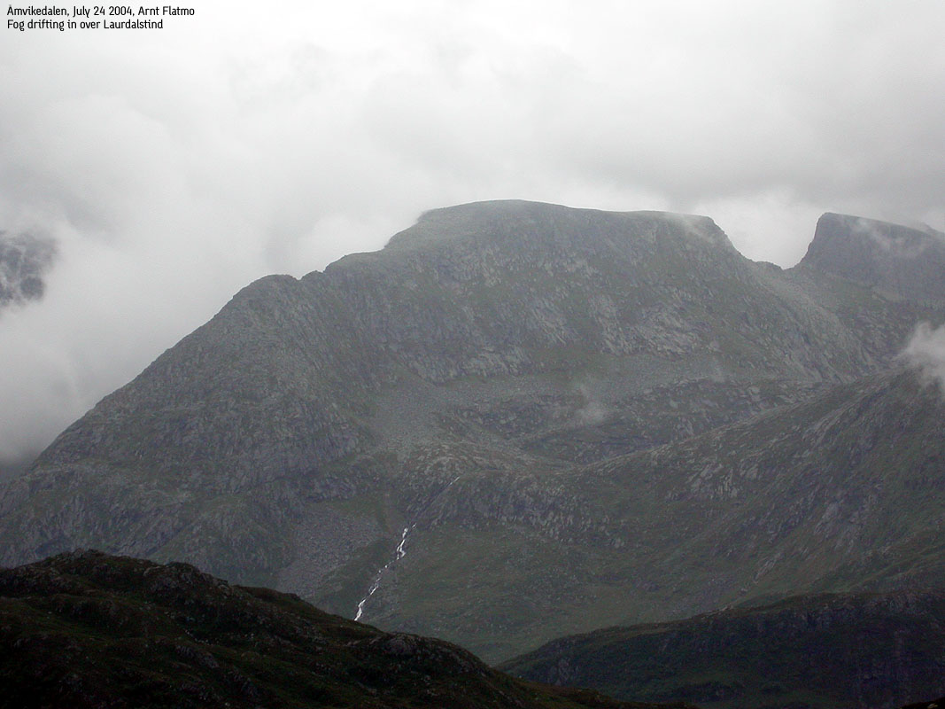
Last night it was pouring down, and the outlook for the week-end wasn't good. I had already cancelled a project with a friend. But this Saturday morning wasn't all bad, so I decided to drive down to Mundheim. If I could see the Rosendal mountains, I would go for Kvannto. If I couldn't, I would go to Yddalshorga (on the Bergen side of Hardangerfjorden). When I arrived Mundheim, the high Rosendal mountains were fogged in, and that's why I had chosen Kvannto. The higher mountains normally attract the fog. I've had success before with this theory. On the 12:15PM ferry across Hardangerfjorden, I could see that Kvannto was free of fog.
The ferry was packed, which is normal for the summer. A long chain of cars were heading towards Rosendal. I managed to exercise great patience, knowing I would be all by myself 8Km down the road. I found the trailhead right away, even if the trailhead isn't exactly heavy marketed. At least there was a trailsign (not by the main road of course) that confirmed I was on the right track. A kid told me I could drive all the way up the forest road, but I decided to park low.
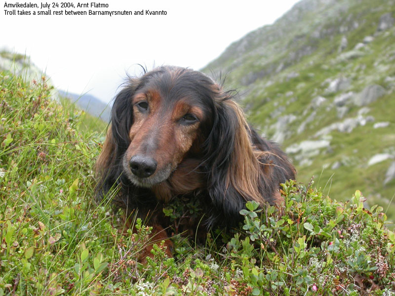
We left the trailhead 13:00PM. A bunch of cows were grassing alongside the forest road. Troll felt utterly small and moved in behind me, going invisible. All cows turned their heads towards this little creature, and I assumed it was best not to stop. We caught up with an elder couple going to Kvitegga, and continued after a small chat. I was a bit confused about the road vs. the trail, but decided to follow the road to the end. At road end, it was apparent that the road had been extended and that a new trail had been made. At least new compared to the map.
The hike up the Kvannto ridge was easy. Troll had walked all the way, except for a short stretch when I left the other hikers. Troll doesn't want to leave people behind, and has to be taken by "brute force". We reached Kvannto summit 14:30PM. It was raining light, but nothing that mattered much. The plan was to go over to Barnamyrsnuten and then descend to lake Barnamyrsvatnet. I changed this plan and decided to hike over all the tops on the plateau, including Skinabergsnuten and Kvitegga.
In the saddle between Kvannto and Barnamyrsnuten, we had lunch. It had stopped raining, and it was a nice place to stay, with views down both sides of the ridge. All sheep on the mountain and down in the valley was staring at us non-stop during the lunch break. Only when I started moving, they continued doing what sheep do. We reached Barnamyrsnuten 15:20PM. We didn't stick around, and continued towards Skinabergsnuten which we reached 15:50PM.
The big bonus with this round-trip hike was to enjoy the great views towards the Ulvanosa and Rosendal "alps" massifs even if clouds swept across these mountains off and on. I followed a vague path from Skinabergsnuten for a while, but lost it. My ambition was anyway to descend northwest to the meadows below Kvitegga. At 700m elevation, it seemed difficult to proceed northwest due to some cliffs. I turned south and reached the meadow after moving carefully down the hillside. From distance, this hillside looks trivial, but a mixture of boulder, turfs and holes made it a bit more tricky. I joined a trail that ran across the meadow but left it when I was next to Kvitegga. After a quick hike up the grassy slopes below Kvitegga, we reached the summit 16:40PM.
When all the mountains had been collected, I started to think about the ferry. I was convinced the next ferry would leave 17:25PM, and since it was Saturday, I was afraid there would be a couple of hours to the next one. Once back on the forest road, I was more running than walking. Troll was a bit confused about the sudden urge to move fast, but ran along. At 15:55PM, I decided to cancel the effort. It still would take me at least 15 minutes to drive, and this was getting way to stressful. We reached the car 16:10PM and I realized if I had been running all the way, I would have made it. Just to be 100% certain, I checked the ferry schedule which I had in my car. One ferry left 16:20PM and the next was leaving 17:50PM. Eureka! The ocean of time allowed for a hot-dog at the gas station in Dimmelsvik. And since it had started to pour down on our way across Hardangerfjorden, the traffic went smooth all the way to Bergen.
Move cursor to read notes, and click on the images to see full version.
Some of the thumbnails may have been cropped to fit the format.


No Javascript:
1 2 3 4 5 6 7 8 9 10 11 12 13 14 15 16 17 18 19 20 21 22 23 24 25 26 27 28 29 30 31 32


No Javascript:
Other hordaland mountains
 Other Kvinnherad K. mountains
westcoastpeaks.com
Other Kvinnherad K. mountains
westcoastpeaks.com

