
|

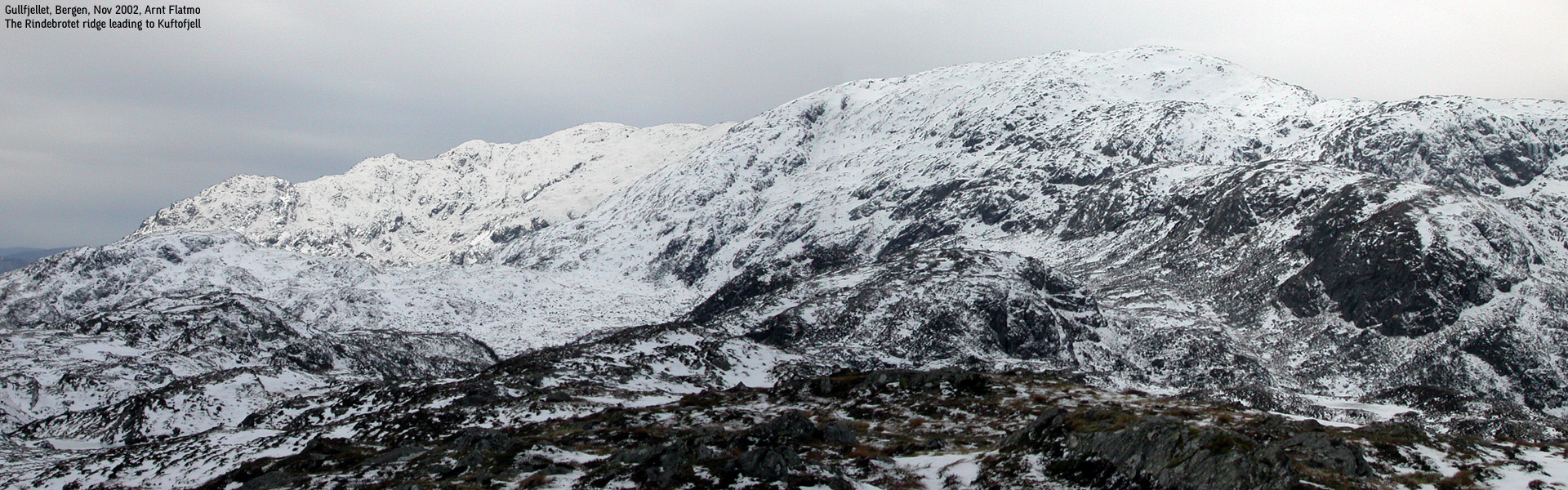
Rindebrotet seen from Trengereidhotten(No Javascript) |
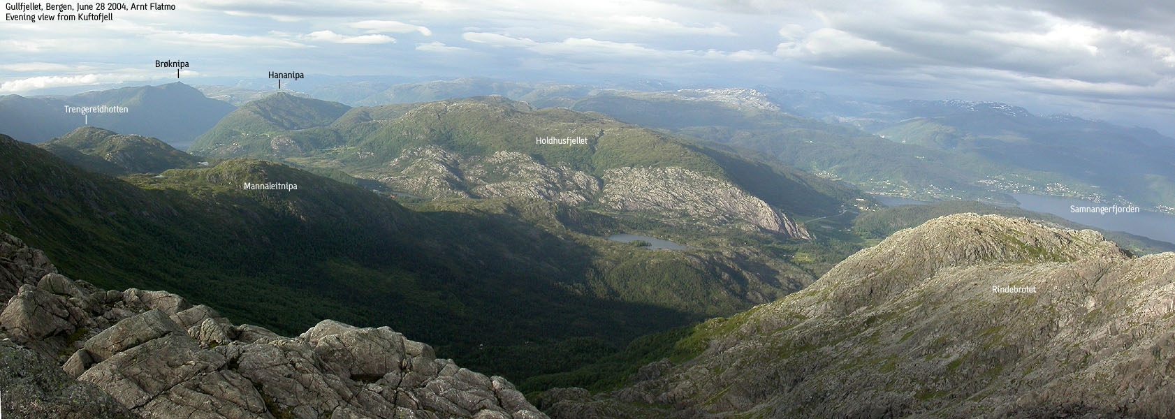
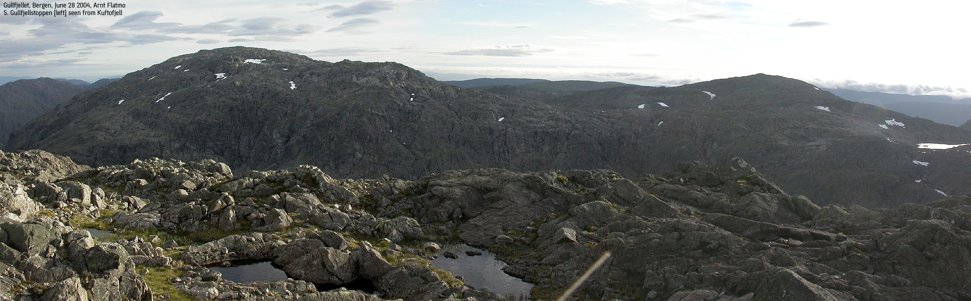
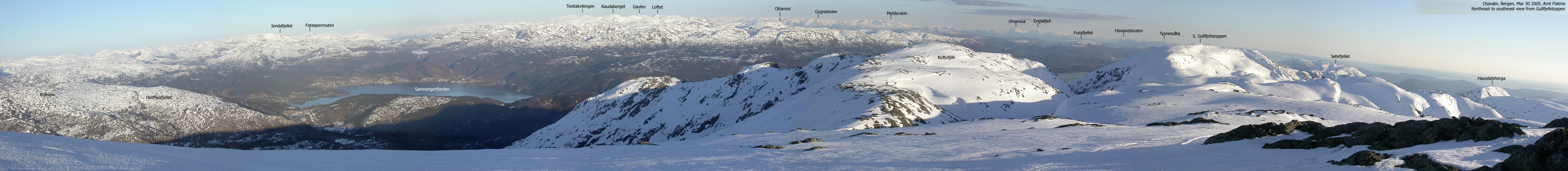
Kuftofjell (also known as Koptofjell) is one of four tops above 900m on Gullfjellet, just east of Bergen. The highest, Gullfjellstoppen (987m) is also the highest mountain in Bergen kommune. Although Kuftofjell is not considered an independent mountain (on this web site), this mountain deserves to be documented due to the great eastern views and the exciting east ridge across Rindebrotet. In addition, the nearest higher independent mountain - Gullfjellstoppen - is nearly 2Km northwest. As such, Kuftofjell is a prominent top and does not appear as a spur of Gullfjellstoppen. Rindebrotet is only a distinct point on the Kuftofjell northeast ridge.
Kuftofjell can be easily accessed if you are anywhere near Gullfjellstoppen or Søre Gullfjellstoppen. This page will not describe access from these summits. Refer to the other pages for more information on Gullfjellet trails. In addition to the off-trail routes described on this page, refer to this page for information about access via Purkedalsgjelet. Instead of heading SW towards S. Gullfjellstoppen, head SE towards Kuftofjell. Easy terrain and needs no further description.
Kuftofjell (M711: 926m, Ø.K: 926m) has a primary factor of 78m towards the higher Gullfjellstoppen (987m). The saddle is found NW of the summit, on the distinct ridge towards Gullfjellstoppen. Ref. Økonomisk Kartverk (5m contours), you cross the 850m contours on the high route, but not 845m. The saddle height has been interpolated to 848m. The trignometric point B33T0643 (921,07m) does not refer to the high point.
Note: Class ratings are in reference to YDS (Yosemite Decimal System).
Note: The trail described below is not necessarily the easiest trail to this mountain.
|
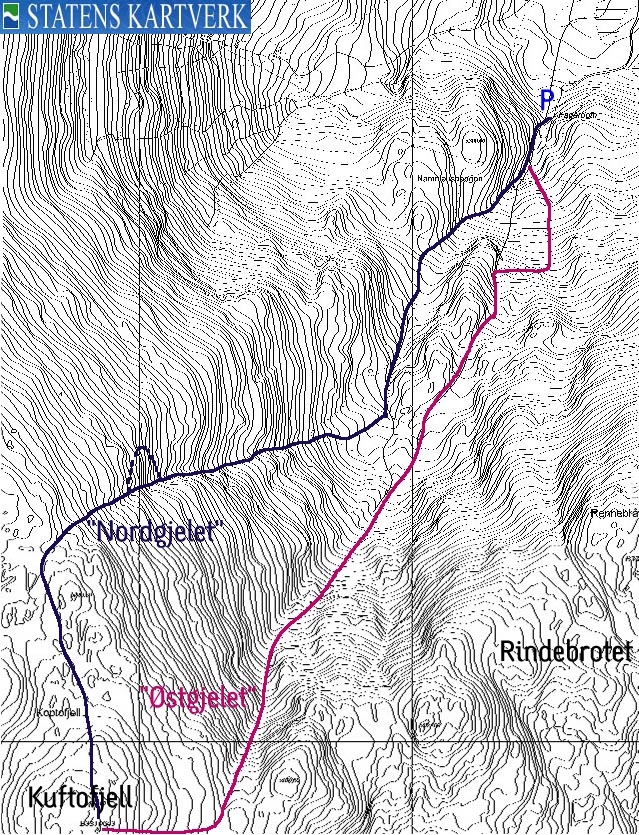
Route 2: Fagerbotnen - Kuftofjell via "Nordgjelet" and "Østgjelet" couloirs (summer)
|
|
This is a round-trip hike that will follow "Nordgjelet" couloir upwards and "Østgjelet" downwards. These couloirs have not been named on the M711 map or on the Norgesglasset 5m contour map. For reference and convenience, these couloirs have been named on this web page. "Nordgjelet" indicates that you have to proceed north from the Kuftofjell summit to reach the high point of this couloir. "Østgjelet" indicates that you have to proceed east from the Kuftofjell summit to reach the high point of this couloir.
It is impossible to classify the level of difficulty. Depending on how you wish to approach this hike, the terrain ranges from class 2 (US) to class 5.x (US). In other words, you may walk, scramble or climb. The average hiker will not be able to freeclimb the couloirs without the use of ropes. If your main goal is to follow the stream up/down the couloirs, you will need to bypass the problematic sections. Inside the couloirs, you will also have the option between easy and difficult scrambling. No need to dwell further on this topic. The routes are fun, and you can do anything you feel like.
See "Note" and "Access" for Route 1 below.
"Nordgjelet"
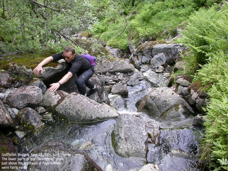
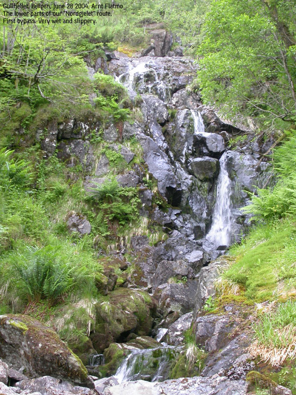
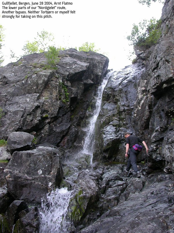
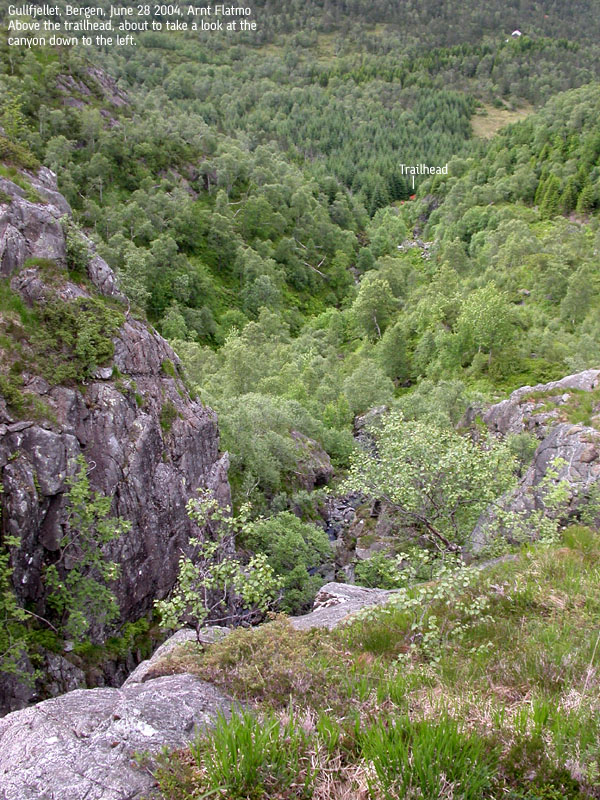
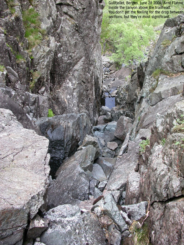
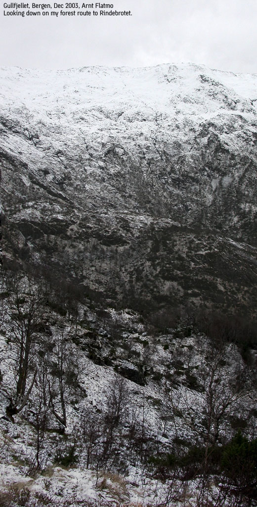
From the parking in Fagerbotnen, walk up a boulderfield on a vague path between the boulders. Once above the boulder, seek down to the stream on your right. Follow this stream all the way until the terrain levels out more gently above 420m elevation. Stay right in the stream fork just above the trailhead. This first section will include 2-3 waterfalls that you may wish to bypass. Even if you consider that the waterfalls match your climbing skills, you still need to consider if you are willing to get soaking wet. You will find bypass routes on either sides of these waterfalls. Of course, the amount of water in the stream is significant. This page was written after a hike in late June, where the amount of water was modest. Following the stream/couloir with lots of water is a totally different type of hike.
Above 420m elevation, the terrain levels out, and you can see both couloirs ahead of you. Kuftofjell and the Rindebrotet ridge is seen up to your left. A distinct ridge up to your left separates you from your descent route. Head towards "Nordgjelet", which is the rightmost of the two couloirs.
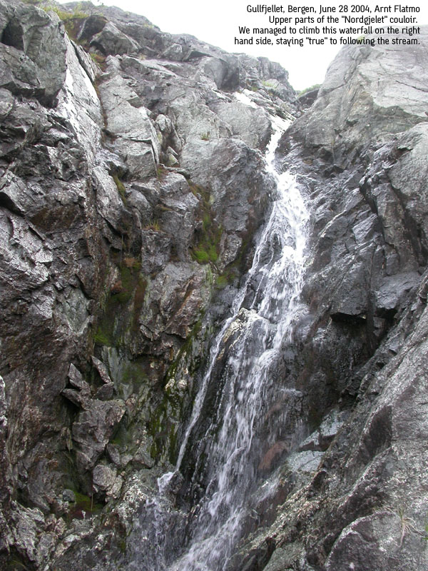
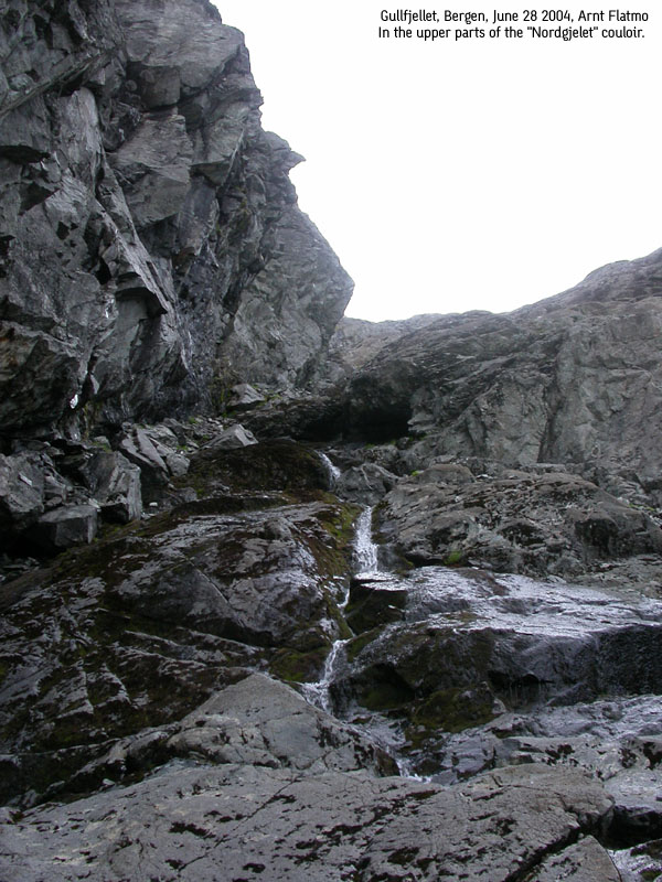
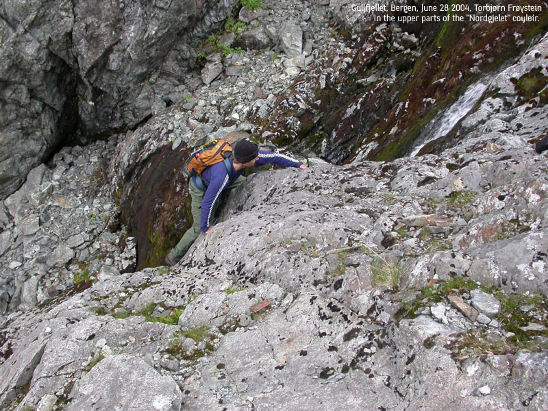
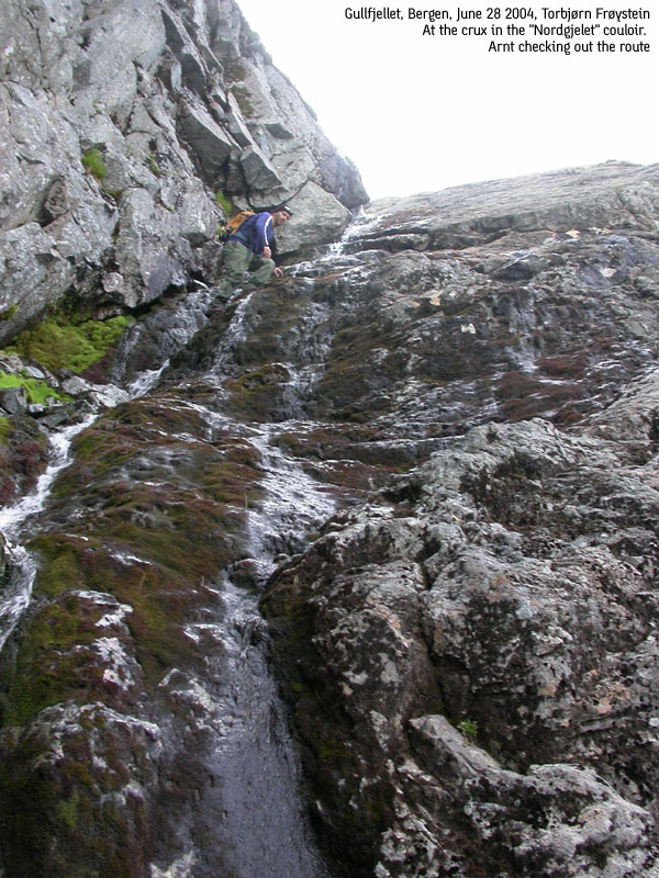
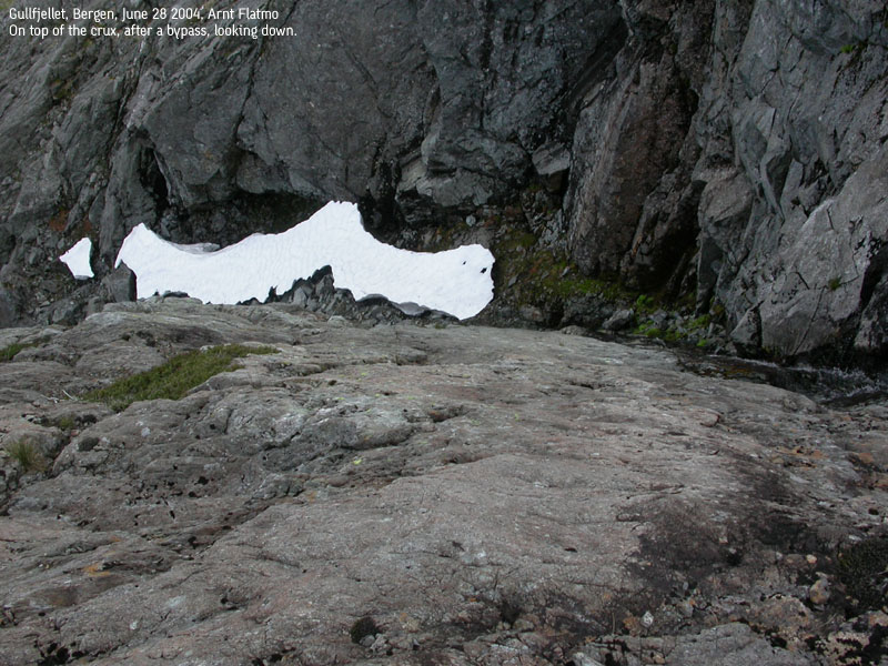
The route upwards is much easier compared to the couloir you have been following so far. With exception of a crux near the top. A rock wall blocks the way, and you will have to climb up to the right in order to complete the true route. This climb is both demanding and very exposed. You may choose to bypass this crux by walking around on the right hand side. Within the minute, you are standing on top of the crux, and the end of the route is just minutes away. Head for some rock that will provide views, and given that weather is OK, you will see Kuftofjell, S. Gullfjellstoppen and Gullfjellstoppen. Head towards Kuftofjell.
"Østgjelet"
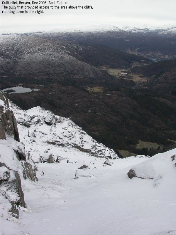
From Kuftofjell summit, proceed east/northeast approx. 250m and find yourself on top of this couloir. A gully is perhaps a more descriptive word here, but it's not always easy to distinguish between the two terms. This is a very uncomplicated route and has a gentle angle. Snow is good. Snow will save you time as the rock/scree in the couloir is loose. It is steep enough to make skiing on your boots quite fun.
At approx. 520m, you are close to your ascent route. Continue your north/northeast route between a hump to your left hand side and Rindebrotet ridge to your right. Follow the stream that runs on your left hand side, if you wish. This route ends in a serious canyon which you under no circumstance should climb unroped. Traverse the hillside to the right and continue down the grassy slopes towards the trailhead.
These routes were on my future to-do list, but were promoted to near-future when Torstein Skage asked me if this terrain was good for "rennekjøring" - skiing in steep couloirs/gullies. The fact of me not knowing was unbearable, so I called Torbjørn Frøystein, who rises to the occasion every time I need a scramble mate. As he had never been on Kuftofjell before, he gave thumbs up for participating in this "project". For me, it would be 6 months on the day, since my last visit to this mountain.
I picked Torbjørn up in the city, and by 18:30PM, we were on our way up the mountain. Still shaking from the very bumpy forest road. The sort of road that will reveal how much you love your car. But comparing to the dirt roads I've seen in the U.S, this was a good road. No complaints. On the contrary - quite thankful for not having to walk all the way into Fagerbotnen.
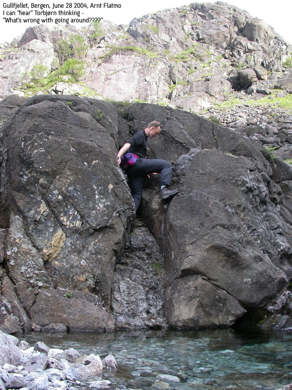
Torbjørn got his eyes on a convenient grassy hillside that would provide a fairly easy start of the hike. My eyes fell on the stream down to the right, and persuaded Torbjørn that the hike would be much simpler jumping from rock to rock, compared to a steep, boring and bushy hillside. He realized that any objection would be futile, and followed in my footsteps, probably with a few firm, but unspoken words.
We bypassed a few sections that were just not within our will-to-risk or will-to-get-soaked limit. Still, there was potential for some creative moves here and there, and I insisted on following the hardest path up the couloir. More unspoken words were most likely uttered behind my back, but more and more I was under the impression that Torbjørn felt this was just pure fun. On my part, this was very useful climbing practice. Several sections were challenging enough, yet without the danger of falling far and a subsequent depressing outlook for the future.
High on "Nordgjelet", things got a bit more complicated. The couloir narrowed in, got steep and only climbing with significant exposure would allow us to complete the upper route of "Nordgjelet" 100%. I climbed up half way and concluded that the further route was doable, but the slippery mountain made me - as my friend Petter puts it - consider my future. I found no point in taking the risk. I suggested that Torbjørn could climb up and take a look for himself, but he trusted my judgement. We bypassed the steep section and were soon on top of the mountain plateau.
While we were taking a short break on Kuftofjell, the current plan was to hike down the Rindebrotet ridge. This plan was changed when we passed "Østgjelet". This couloir was wide and not very steep. Some snowfields in the upper section provided an easy way out of the loose scree/rock area. We continued a route parallel to our ascent route, but it wasn't possible to follow this couloir all the way down the hillside. The couloir turned into a hilarious gorge/canyon with several levels of waterfalls. These were just not doable without rope, and we followed the parallel grassy hillside back to the trailhead. The hike had taken 3 hours altogether. Despite of the "guide with some sort of a problem", Torbjørn acknowledged that the hike had been quite fun. The incoming fog had now covered all mountain tops, and as such, the timing was excellent. This is surely one way of "killing off" a Monday afternoon.
Move cursor to read notes, and click on the images to see full version.
Some of the thumbnails may have been cropped to fit the format.
Pictures are presented in the order they were taken.
Ascent


Summit views & descent


No Javascript:
1 2 3 4 5 6 7 8 9 10 11 12 13 14 15 16 17 18 19 20 21 22 23 24 25 26 27 28 29 30 31 32 33 34 35 36 37
|
Route 1: Fagerbotnen - Rindebrotet - Kuftofjell (winter)
|
|
If you choose to park at the start of the forest road that leads to Fagerbotnen, then you add 2,75Km of walking to the distance above, and 200m of vertical gain.
From Bergen, follow highway E16 towards Oslo. After you leave the Arnanipa tunnel after Indre Arna, continue on E16 for 7Km to the E16/highway 7 junction at Trengereid. Turn right onto highway 7 and follow this road for 4,8Km. Exit right towards "Os" and follow the Os road for 2,7Km. Exit sharp right onto a smaller road. After 400m you reach a Y fork. Go left and drive another 400m. This is where the road to Nordbø ends. You can drive additional 2,75Km up the forest road until road end in Fagerbotnen. In summer, gates may be closed. An old sign posted by the former mining company says this is restricted area. It is fair to assume that this restriction is no longer valid. The road is rough, but there should be no problems if the road is dry and you drive carefully.
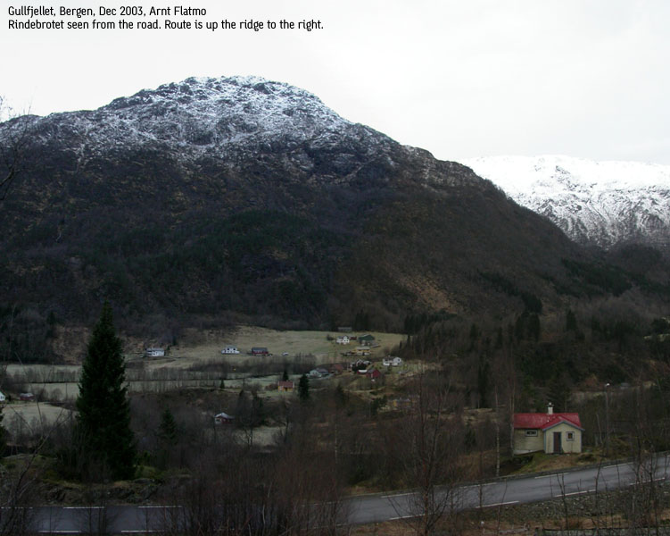
Park by the old buildings in Fagerbotnen. Walk up a boulderfield on a vague path between the boulders. Once above the boulder, the rule of thumb is: "Left is good". Ahead of you are two distinct cliffs, and beyond, steep mountain side. Hike upwards and when you a see a small top far left in the horizon, set course towards this top, and hike up a gully right of the top. The idea is to bypass the center ridge on the left hand side.
When you have the center ridge cliffs directly above you, then go as high as you can towards the cliff and then seek left. In a while, you will encounter a gully coming down from the right. You can safely hike up here. Within a few minutes, you will reach Rindebrotet 757m point. Since this description is valid for winter, then an ice axe is a very useful tool. Crampons are useful if the snow is hard or icy. In summer, you can scramble the center ridge head on.
From Rindebrotet, pass the lake on the other side on the right hand side and aim directly for the next hump on the ridge - point 829m. Access to this hump can be quite steep. The best thing is to access this point by seeking left. Once on top, you have some cliffs in front of you. You can seek left or right, or climb the cliffs down on an obvious route.
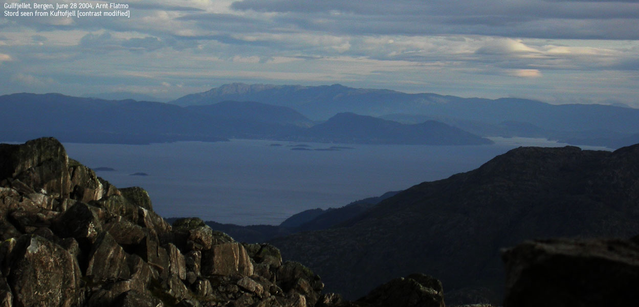
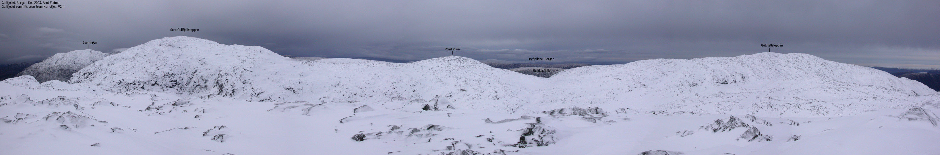
Proceed to point 871m, the third hump on the ridge. You can also bypass this hump on the left hand side. The descent from this hump is minimal before you take on the final yards towards Kuftofjell. The summit is marked by a very small cairn. Just a few rocks, actually. From this point, you see the entire Gullfjellet plateau, from S. Gullfjellstoppen to Gullfjellstoppen. The ridge towards Gullfjellstoppen is easy to identify. Descend your ascent route.
I had been looking forward to this hike for quite some time. I had been hiking the Rindebrotet ridge in Oct 1999, and remembered the ridge to be steep. It also looks steep! I remembered there was some scrambling involved, but the details had now escaped me. It was time to explore this ridge one more time.
This ridge is steep and strenuous, and I decided to leave the dog back home. I would have to carry him up the snow anyway. There was also some potential scrambling, so it was best to travel "light". The forest road to Fagerbotnen was in good condition, and I could drive all the way up the forest. I left the trailhead 11:05AM and headed up the ridge. When I saw the steep cliffs high above, I wandered if I was into something spooky. There was not a lot of snow, and the mountain was icy. I decided to seek left and see if I could find a bypass the steep parts.
When I just was just below the cliffs, I wondered if I should attempt the ridge head on. It looked a bit spooky, and I decided to walk alongside the mountain to find a safer route. I soon did, and reached Rindebrotet 12:10PM. The rest of the route was more or less trivial. There was considerable more snow. I had put on crampons below Rindebrotet. With axe and crampons, I didn't have to look hard for a way down the ridge humps.
I reached Kuftofjell 13:00PM, and felt blessed with the weather. The wind was hardly noticeable, and it was neither snowing or raining. I considered continuing the hike to Gullfjellstoppen, but I had watched the ugly weather in the southeast moving in, little by little. As I had been wandering back and forth on the ridge, looking for routes, I realized that I would benefit from following my tracks down the mountain. I headed down immediately. I was back at the car 14:05PM. 14:10PM it began snowing, and I could vaguely see the mountain as I drove home. And then the weather turned really shitty.
Move cursor to read notes, and click on the images to see full version.
Some of the thumbnails may have been cropped to fit the format.
Pictures are presented in the order they were taken.


No Javascript:
1 2 3 4 5 6 7 8 9 10 11 12 13 14 15 16 17 18 19 20 21 22 23


No Javascript:
 Other hordaland mountains
Other mountains in this area
westcoastpeaks.com
Other hordaland mountains
Other mountains in this area
westcoastpeaks.com


