
European Mountains, Slovakia
Kriván (2495m)
| Primary factor: | 245m | ||||
| Hiked: | July 2013 | ||||
| See also: |
| ||||
| See also : | Other European mountains on westcoastpeaks.com |

Kriván
(Click for larger image)
Introduction
Kriván (Polish: Krywan) is located in the western part of the High Tatra (Vysoké Tatry) mountain region, and is also one of the most popular Tatra peaks for several reasons; only a handful (or so) Tatra peaks can be visited without a mountain guide (and of the few - Kriván is the second highest), the mountain is easy to hike and has for a long time been a national symbol in Slovakia. And last, but not least - the view from the summit is awesome!! (see the below picture)
The main trailheads are; Strbske Pleso (1355m) and Tri Studnicky (1140m). This page will however describe the route from Biely Váh (1210m). This is the second shortest route to Kriván and the route eventually joins the other main routes at 1450m. It is however not a well worn route and if you want to follow a good trail from the beginning, Strbske Pleso or Tri Studnicky are better choices. The marked mountain path from 1450m and up to Kriván is straightforward and easy to follow. The shortest route in distance is the green route from Tri Studnicky and up Krivan's southwest ridge.
Important:
The marked trails in the High Tatras are closed from 1st of
November to the 15th of June! This also applies to the Kriván
trails. According to summitpost.org, it is not even allowed to climb Kriván
on skis during winter.

Tatras seen from Kriván
(Click for larger image)
Primary factor:
Kriván (2495m, UTM 34 U 427106 5446039) has a primary factor of 245m towards the higher parent Rysy (2503m). The saddle is found in a pass (34 U 430969 5447728) between of Koprovsky štít and Hlinská veža. The adjacent contours are 2260m and the saddle has been interpolated to 2250m.

Kriván seen from the mountain trail
(Click for larger image)
Google map
Google's interactive map. You can zoom, pan and click on the markers.
|
|
Route descriptions
| This disclaimer is regarding all of the literature and instructional guides posted on the westcoastpeaks.com website. These instructions are guidelines only, and should not be used in lieu of common sense or judgment when attempting any of the actions involved or instructed. Westcoastpeaks nor myself will not be liable nor will it indemnify any form of compensation to anyone who has injured, harmed or even killed themselves or others while following any of the instructions written within the website. It should be noted by any persons willing to undertake any of the instructions provided that mountains offer varying levels of risk, regardless of size or incline. Risks to be considered are as follows but not limited to: wild animals, weather, the terrain, bad judgment, inappropriate or insufficient equipment, improper training or experience and of course, bad luck... |
|
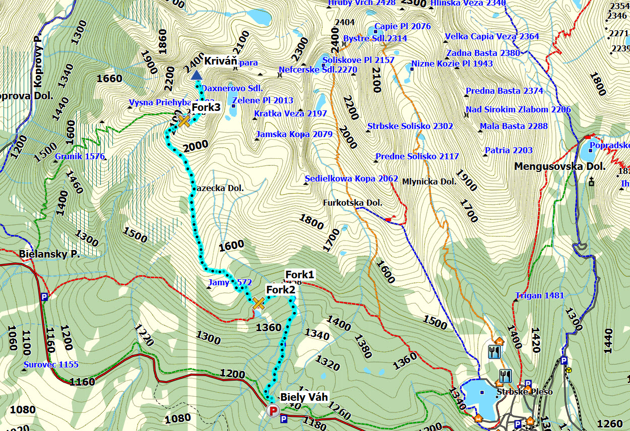
Route 1: Biely Váh - Kriván
|
|


This route description is valid per July 2013
Access
(all distances are approx. distances)
The starting point for this route description is the village Strbske Pleso - located at the southern foothills of the Tatra mountains. You can get there by train from the nearby town Poprad.
Drive approx. 4,6km to the west to the Biely Váh bus stop. Look for the Kriván signpost (N49.12106 E20.01492). You need to find parking alongside the road without blocking for other traffic. I can only assume that it is allowed to do so...
The route:
")
The route (Google Earth)
(Click for larger image)
- Follow the
blue route to Kriván and Jamske Pleso. The hiking time
to Jamske Pleso is estimated to 1 hour. This is not a well worn
route. You'll be wet after rain...
- After 2,2km you reach the
Odbocka
trail fork (N49.13614 E20.01661) at 1460m where you join the trail
from Strbske Pleso. The hiking time to Kriván is estimated to 3h:25m
from here. Turn left (west)
- Continue 0,4km and you reach the
Pri
Jamskom Plese trail fork (N49.13429 E20.01268) at 1450m. Turn right
(northwest) onto the forest and
mountain trail to Kriván. If you
continue straight ahead, you'll end up at Tri Studnicky.
- Follow
this trail for 4,8km to the summit
(N49.16283 E20.00012), which is marked by
a cross. During the final
150 vertical meters you might need to look a bit harder for the
trail than you've had to do so far. This is also the steepest part
of the route, so don't fall! Not that you'll be falling off the
mountain, but it would be an awkward place to have an injury...
Note: at 2120m, you'll reach a trail fork (N49.15702 E19.99756). The green route from Tri Studnicky joins in here. Make sure you continue in the direction of Kriván...
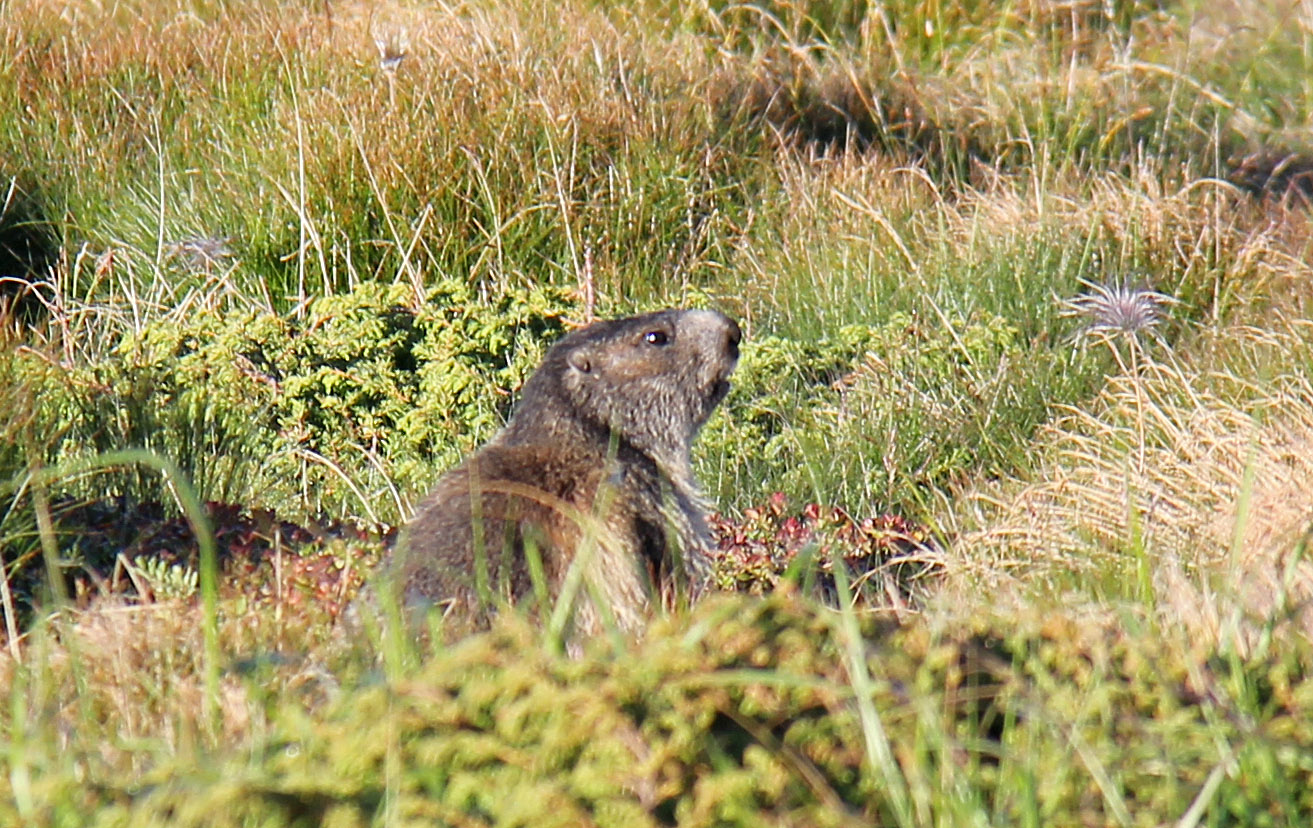
- Enjoy the views and be on the lookout for marmots!

High Tatra peaks seen from Kriván
(Click for larger image)
Pictures and Trip reports:
- Kriván, July 8 2013
 westcoastpeaks.com
Other European mountains
Other Norwegian mountains
westcoastpeaks.com
Other European mountains
Other Norwegian mountains