
Norwegian Mountains, Møre og RomsdalKjøsen, 1117m (Kjøsa)

Kjøsen
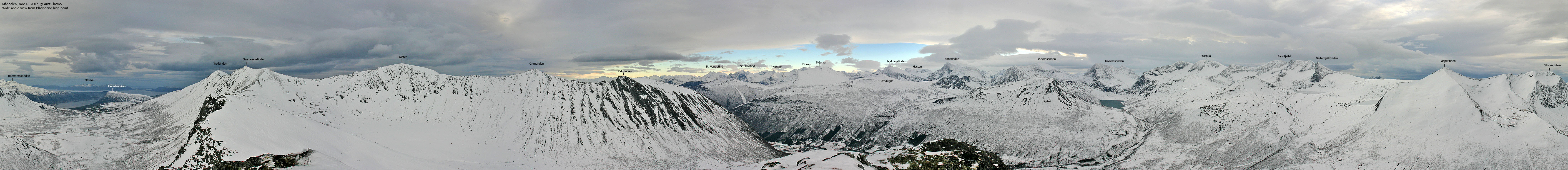
IntroductionKjøsen is a satellite peak of Trollvasstindan - a distinct and rugged mountain (with two equally high tops), and part of the spectacular mountain range stretching between Tresfjord and Måndalen. Kjøsen is a "friendly" top, very accessible from the Måndalen valley and especially due to a forest road that runs up to 550m elev. While Kjøsen offers a nice hike, it also offers a good run down on skis. You can let the skis flow from the summit at 1117m and all the way down to the winter trailhead at 220m without stopping. Kjøsen is also a good place to view the "back-country" of the rugged Tresfjord - Måndalen mountain range. Being on top on the higher peaks such as Nonstinden, Middagstinden, etc., you don't really see what's beneath you. Primary factor:Kjøsen (Norge 1:50,000: 1117m, Økonomisk Kartverk.: 1116,98m , UTM 32 V 413529 6929486) has a primary factor of 187m towards the higher parent Trollvasstindan (1422m). The defining saddle (approx. UTM 32 V 412786 6927801) is found between Klumpan and Trollvasstindan. Ref. Norge 1:50,000 (20m contours), the saddle is within the range 920-940m, interpolated to 930m.
Google mapGoogle's interactive map. You can zoom, pan and click on the markers.
Trail descriptions
Notes: Class ratings are in reference to YDS. Click here for more information.
The trails described below are not necessarily the *easiest* trails to this mountain.
Access (all distances are approx. distances) Locate the place Måndalen, approx. 20Km west of Åndalsnes. Locate the Måndalen valley road on the north side of the river Måna (this road has two entrances/exits). When you come from Vestnes, turn right when you see the "Gyrodesinfeksjon" sign (per Nov. '07) on the left-hand side of the road. This road exit is approx. 40Km from the E39/E136 junction in Skorgedalen. Drive 5,5Km up this road and you'll enter a road junction. Turn left here and drive 550m until you reach another junction. To your right is the start of the toll road towards Skarsetra, but closed in winter. Find parking on the other side of the bridge, if possible. The route

The route to Kjøsen
From the parking, follow the road 100m until you reach the Skarsetra/Månvassetra road junction. Turn left here. Follow the forest road up to 470m elevation, and instead of crossing the bridge, continue on the west side of the river. You have the ridge to Kjøsen just ahead of you. Aim for the lower part of the ridge and access it on the east side. There is a slightly steep section leading up to Øvste Aksla at 936m. You'll find two cairns here. Follow the ridge upwards. You'll pass a slightly narrow section before taking on the - slightly steep hill up to Kjøsen summit. Steep in this context, means that if the snow is hard, you should wear crampons. Kjøsen summit is marked by two tall cairns on the north side (the high point) and one lower cairn on the south side.
Trip reports and pictures
Other pictures:
|


