
|


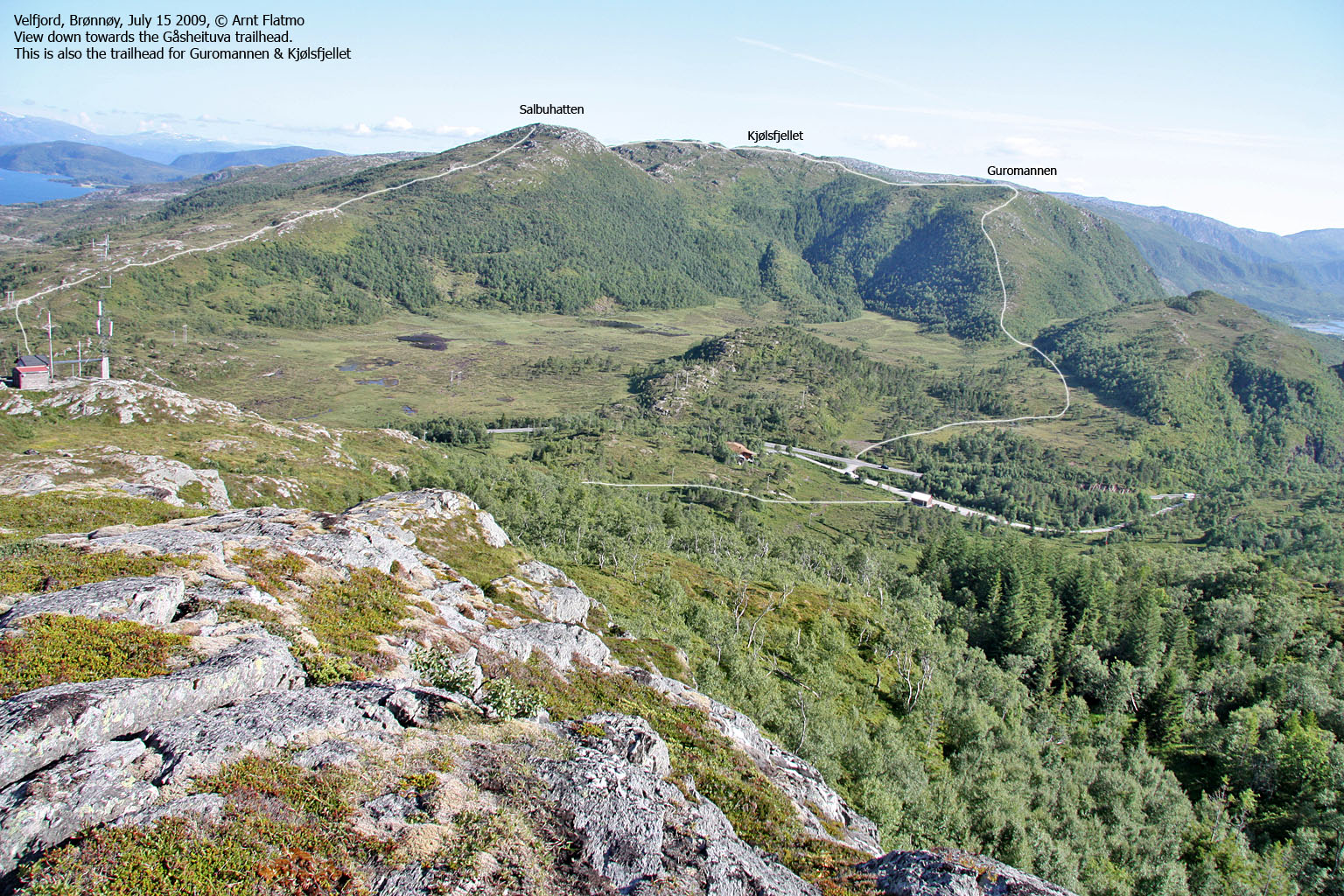
Guromannen, Kjølsfjellet and Salbuhatten form a horseshoe on the south side of Gåsheia - the pass you cross as you drive between Velfjorden and Brønnøysund. One of these tops normally figure on the list of Fjelltrimmen tops in Brønnøy and Sømna kommuner.
Access from Gåsheia to Salbuhatten or Guromannen is easy, and you can reach Kjølsfjellet from either side in uncomplicated terrain. Guromannen is not really a top, merely a viewpoint or Kjølsfjellet's western shoulder.
Should you choose to visit Kjølsfjellet, then a roundtrip is strongly recommended. You'll end up very close to where you started. Excellent views towards Velfjorden.
Kjølsfjellet (Norge 1:50,000: 355m, Økonomisk Kartverk: 355,8m ~ 356m, UTM 33 W 379265 7265153) has a primary factor of 178m, towards the higher parent Skogmofjellet (459m). The saddle (approx. 33 W 378960 7264303) is found W of Lake Storbutjørna, south of Kjølsfjellet. Ref. Økonomisk Kartverk (5m contours), the saddle is within the range 175-180m, interpolated to 178m.
Salbuhatten (Norge 1:50,000: 334m, Økonomisk Kartverk: 335,4m, UTM 33 W 379630 7265650) has a primary factor of 52m, towards the higher parent Kjølsfjellet (356m). The saddle (approx. 33 W 379603 7265546) is found between Salbuhatten and Kjølsfjellet. Ref. Økonomisk Kartverk (5m contours), the saddle is within the range 280-285m, interpolated to 283m.
Google's interactive map. You can zoom, pan and click on the markers.
Notes: Class ratings are in reference to YDS. Click here for more information.
The trails described below are not necessarily the *easiest* trails to this mountain.
|
Gåsheia - Guromannen - Kjølsfjellet - Salbuhatten (summer/autumn)
|
|
Access
(All distances are approx.)
From Brønnøysund, follow RV17 eastbound to Skillvika. Turn left onto RV76 (Mosjøen) and drive 2,5Km to the public parking (on the left-hand side) on Gåsheia.
The route
Guromannen:
From the public parking, cross the road and a meadow (can be wet) while aiming for the ridge leading up to Guromannen. Once you enter the ridge, the ground is far less wet and muddy. Follow the ridge up to Guromannen cairn, which has a container that may hold a visitor register.
Kjølsfjellet:
Backtrack 150m and head eastbound towards Kjølsfjellet. Half-way across, you'll join the path from Skogmo. The high point has a small cairn.
Salbuhatten:
From Kjølsfjellet, head northeast (off-trail) towards Salbuhatten. The terrain is gentle, but it isn't easy to figure out the correct route until you see the small lake below Salbuhatten. In front of Salbuhatten, cross a fence on a ladder and follow a path diagonally up the hillside. You'll reach a cairn (that may have a visitor register inside a container), but the high point (marked by a trig. point marker) is found 85m to the southeast.
Descend (on path) Salbuhatten's north ridge and join RV76 300m east of the parking.


No Javascript:
 westcoastpeaks.com
Other Nordland mountains
Other Norwegian mountains
westcoastpeaks.com
Other Nordland mountains
Other Norwegian mountains

