
|

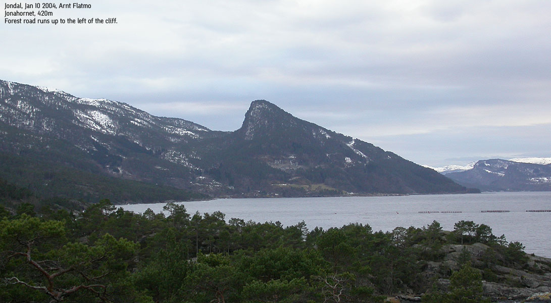
Jonahornet seen from northeast(No Javascript) |
Jutulen i Jonshornet
"Udenfor Jondal i Hardanger er en brat, høi og nø-gen Fjeldkegle,
Jonshornet, hvor der i gamle Dage boede en Jutul eller Rise, som hedte Jon i Hornet.
Han eiede hele Jondal, der saavel som Fjeldet har faaet Navn efter ham. Denne Jon
var groveligt rig og havde en ustyrtelig Mængde store Faar.
Med Skindene af disse reiste han ofte ind til Hansebryggen i Bergen og drev Handel;
og vare hans Skind som store Koskind....."
Andreas Faye: Norske Folke-Sagn (Norsk Folkeminnelags Forlag, 1948)
The excerpt above talks about a mythical figure named Jon who lived on the Jonahornet mountain outside Jondal. Jon was wealthy, owned everything in Jondal and had a large amount of black sheep. He often went to Bergen and traded with the skins. Those who understand Norwegian can read the story about one of his trips to Bergen here.
From a mountain perspective, Jonahornet is an exceptionally cool forest hill due to its characteristic appearance. Unfortunately, the view is spoiled by high trees on the summit. One has to search below the summit in order to find viewpoints towards the distant mountains. A panoramic view is impossible to get here. The hill is fairly easy accessible from Selsvik, a few Km north of Jondal. High forest roads takes you through the lower forest and despite some steep and unfriendly cliffs, the summit can be reached without any form of technical difficulties.
Primary factor:
Jonahornet's primary factor towards the higher Gulbergnotten is 122m. The saddle is SW of Vetlehornet. On the M711 20m and Norgesglasset 5m map 300m contours from Jonahornet and Gulbergnotten almost touch. The saddle is interpolated to 298m.
Note: Class ratings are in reference to YDS (Yosemite Decimal System).
Note: The trail described below is not necessarily the easiest trail to this mountain.
|
Selsvik - Jonahornet, round-trip (winter)
|
|
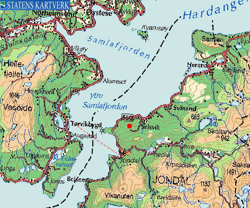
Access
From Bergen, follow highway E16 towards Oslo. After you leave the Arnanipa tunnel outside Indre Arna, follow highway E16 7Km to the highway E16/7 junction at Trengereid. Go right and follow highway 7 for approx. 40,1Km to Norheimsund. At the main traffic junction in Norheimsund, exit right and follow highway 49 for 12,3Km and exit left to the Tørvikbygd-Jondal ferry.
From Jondal, exit left in the junction when you depart from the ferry. Follow highway 550 northbound for approx. 5,3Km and turn right when you see the "Solesnes Stein/Selsvik" sign. Find parking alongside the road.
The route
Note: Description is valid for winter. Can be hiked in summer, but there are trails that provide a quicker ascent to the summit.
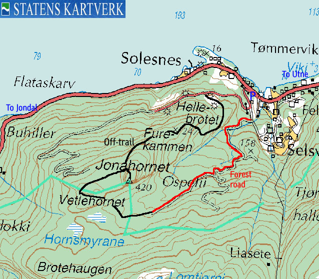
Follow the paved road upwards. After approx. 300m, notice a road that forks off to the right. You will be coming down this way. Continue yet another 100m and exit onto a forest road next to a stream. Follow this road as long as you can. Stay right in all forks.
I've been told the summer trail begins where the forest road ends and climbs Jonahornet on the east ridge. As I hiked in winter, I can only supply a doable off-trail route that eventually get you to the summit, and give you all angles of this forest hill.
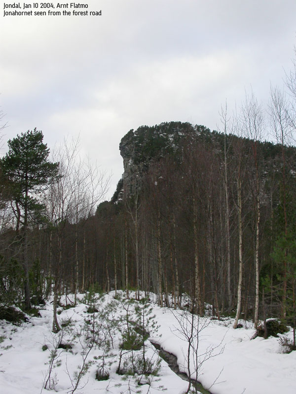
At the forest road end, you have the Jonahornet and Vetlehornet cliffs up to your right. You see a low pass between the two, and a gully leading up to this pass. This may be a doable scramble shortcut. Remains to be verified. Set a course towards the cliffs and hike along the cliffs until a natural ascent presents itself. When you are on the Vetlehornet ridge, set a northeast direction. There is no need to hike via Vetlehornet summit. Eventually you will reach a meadow where Jonahornet looks really cool, like a sleeping bull.
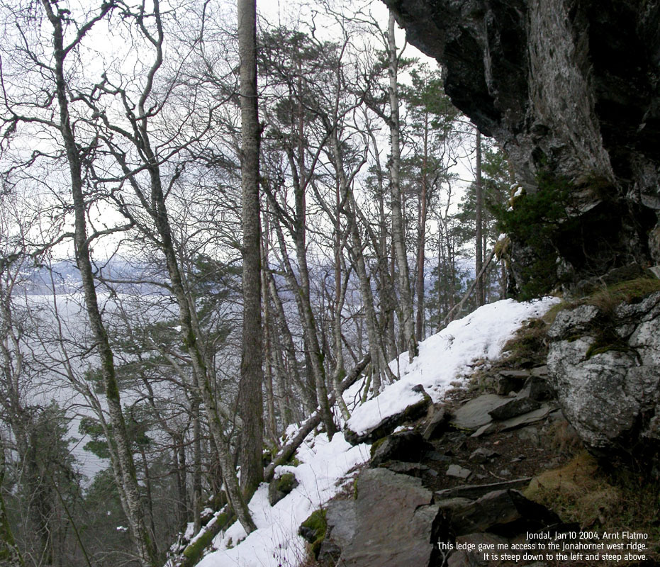
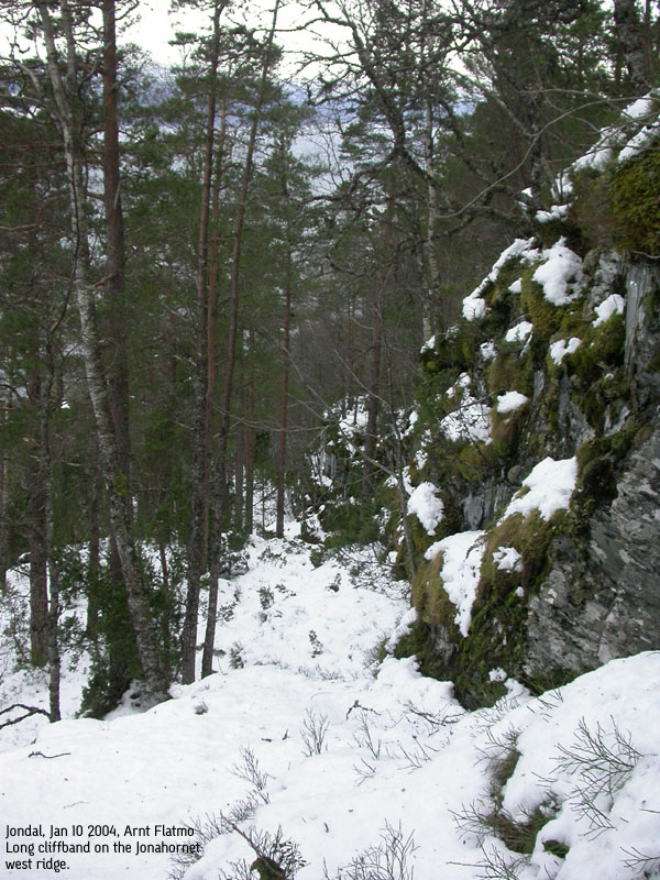
The cliffs are steep, so seek left along the cliffs. You will reach a boulderfield (may not be visible in the snow), but you will identify it as it is the first possible ascent route. Hike upwards and you will reach a distinct ledge with overhang. Go left until you find the first possible place to ascend. You now enter a long cliffband. Walk along this cliffband upwards until you see a way to proceed one level up. Now you have a easy walk up to the summit.
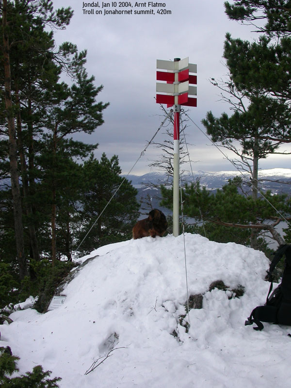
The summit is marked by a red/white trig. point. Just before the summit, you will see a green mailbox on a tree, containing the summit register. Sign in. To get some hilarious view down the cliffs, descend a little from the summit. This is a good place to check if you have a head for heights.
Descend all the way to the long cliffband. Instead of descending to the ledge with the overhang, continue down along the cliffband. In a while you see a hilarious drop down towards the fjord. It is time to seek right. After adjusting the course, you are now on the ridge from Jonahorn to Furekammen.
As you get to Furekammen, get off the ridge on the right hand side, but maintain the general direction towards the fjord. You will eventually reach the place where they extract slate. It may be sound to get off the ridge before you reach the slate area, as there are steep cliffs above. Follow the maintenance road back to the trailhead.
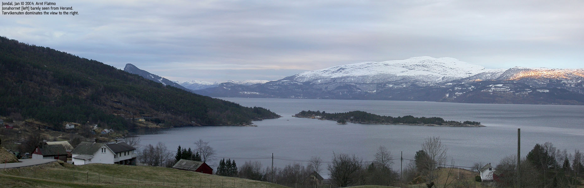
This day didn't turn out as planned. The goal was Samlen (686m) near Herand, northeast of Jondal. Samlen was high on my primary factor list, and it was time to collect. I left Bergen early morning and reached the 09:15AM ferry with M/S Jondal from Tørvikbygd. Within the hour I was standing at the Samlen trailhead, looking at a monstrous, icy, and insanely steep mountain side. I could vaguely imagine a way to get up on a good summer day, but with all the ice...
I drove down to Herand, picked a random house and rang the doorbell. An elder man opened the door, with a grin of discomfort. "I'M NOT LETTING YOU IN", he yelled. I smiled back and explained my business in a polite manner. He put on a seriously concerned face and shook his head. "DON'T GO UP TO THE MOUNTAIN!", he said. I was thinking how I should weight this information. Then he stated that he knew the mountain inside out and with all the ice, this would be a dangerous endeavour. This information helped, and I kissed Samlen goodbye that very moment. "NOW YOU HAVE TO GO", he yelled. I thanked, again polite, for the information and drove back to Jondal.
On the way to Jondal, a pointy, neat hill presented itself in the horizon. I quickly realized this would have to be the hill named Jonahornet on the map. OK, that would be my destination for today. The map indicated that a forest road would take me high in the forest. Good! And then it's just a matter of getting up some cliffs.
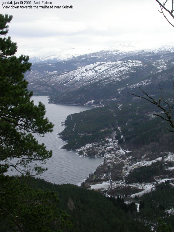
I left the trailhead below Selsvik at 11:15AM. I decided to hike from close to sea level, as this hill wasn't very high. After 300m, I realized it wasn't possible to drive higher than 60 vertical meters anyway. I followed the mountain road to road end. I walked on snow the whole way, but it wasn't very deep. The dog, recovering from (yet another) back injury, was firmly seated in the backpack. From road end, it was time to go backcountry. The route was fairly obvious all the way. I had to walk around Vetlehornet in order to gain access to Jonahornet. I had been looking at a shortcut from the road end, but decided I would make a round-trip of the hike, and see the hill from all angles.
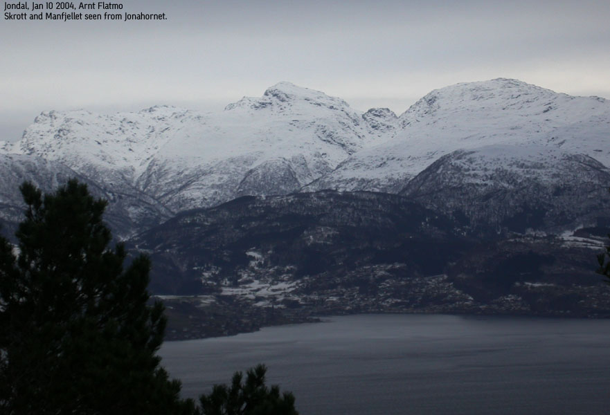
On a meadow between Vetlehornet and Jonahornet, I found Jonahornet wild and rough. I quickly decided to seek left and explore rather than considering a way up the steep cliffs. Access to the ridge was easier than I hoped for. Up to a ledge, then up along a cliffband, and then we could arrive the summit 12:40PM. I signed the summit register. Petter and I were surely the first 2004 visitors on Skrott a week earlier, and I hoped I would be the first 2004 visitor on Jonahornet as well. But then I saw that two people had been up here 01.01.04, and I was clearly defeated. While Troll was enjoying his lunch-box, I explored the summit area for places to get a view. I cursed the trees on top. Looking down the 120m drop on the summit's south side made my head dizzy.
I seriously considered following the high ridge all the way down towartds Furekammen, but this never happened. I didn't want to get blocked by a cliff and have to turn around. I went back to the long cliffband. Instead of descending down to the meadow, I continued down the cliffband. When the drop down to the fjord gave me nausea, I sought back onto the high ridge. I followed the high ridge for a while, but descended towards the inner valley when I detected friendly terrain. Suddenly I found myself at the slate work area, followed the construction road back to the trailhead and reached the car 13:40PM.
On my way to the ferry, I called Laila Bergsagel, who had done me a big favour by supplying corrective information on a Jondal panorama I had taken from Skrott (and thanks to Magnar Sollesnes who provided the correct information) I had annotated text on the Jondal mountains, and messed up in the process. Laila invited me on coffee at Meieriet Gjestestue (guesthouse), which she runs. The guesthouse looked very inviting. Now I have a place to stay the week-end when I go after the serious Jondal mountains. Thanks to Laila for the coffee, a nice chat and the hospitality. On the way across Hardangerfjorden, the mountains disappeared in some really nasty weather. I was happy with was achieved this Saturday early in January, although we didn't reach the top of the world.
Move cursor to read notes, and click on the images to see full version.
Some of the thumbnails may have been cropped to fit the format.
Pictures are presented in the order they were taken.


No Javascript:
1 2 3 4 5 6 7 8 9 10 11 12 13 14 15 16 17 18 19


No Javascript:
 Other hordaland mountains
Other Jondal K. mountains
westcoastpeaks.com
Other hordaland mountains
Other Jondal K. mountains
westcoastpeaks.com

