
Norwegian Mountains, Sogn og FjordaneSvartevassegga, 889m
|
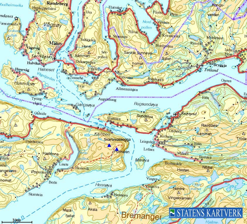
| Fylke/Kommune : | Sogn og Fjordane/Bremanger | ||||||
| Maps : | 1118-I Måløy (Statens Kartverk, Norge 1:50 000) | ||||||
| Primary factor : |
Svartevassegga: 889m Hornelen: 110m Slettheia: 51m Uraheia: 28m |
||||||
| Hiked : | June 2009 | ||||||
| See also : |
|
||||||
| See also : | Other Sogn og Fjordane mountains on westcoastpeaks.com |

Hornelen and Svartevassegga
(Click for larger image)
While Svartevassegga is the highest point on the Bremangerlandet island, Hornelen is the notable top. Hornelen is well-known across southern Norway (and even beyond) for the spectacular 860m cliff that rises steeply above the fjord. It is claimed that this is the tallest sea cliff in northern Europe. Hornelen has over the centuries also been an important landmark for ships at sea.
Hornelen is a very popular mountain, and several routes lead up the mountain. Berle (southwest) and Hunskår/Hornskor (northwest) are the most popular trailheads, but some also come by boat and hike from the south. This page will describe the route from Hunskår/Hornskor.
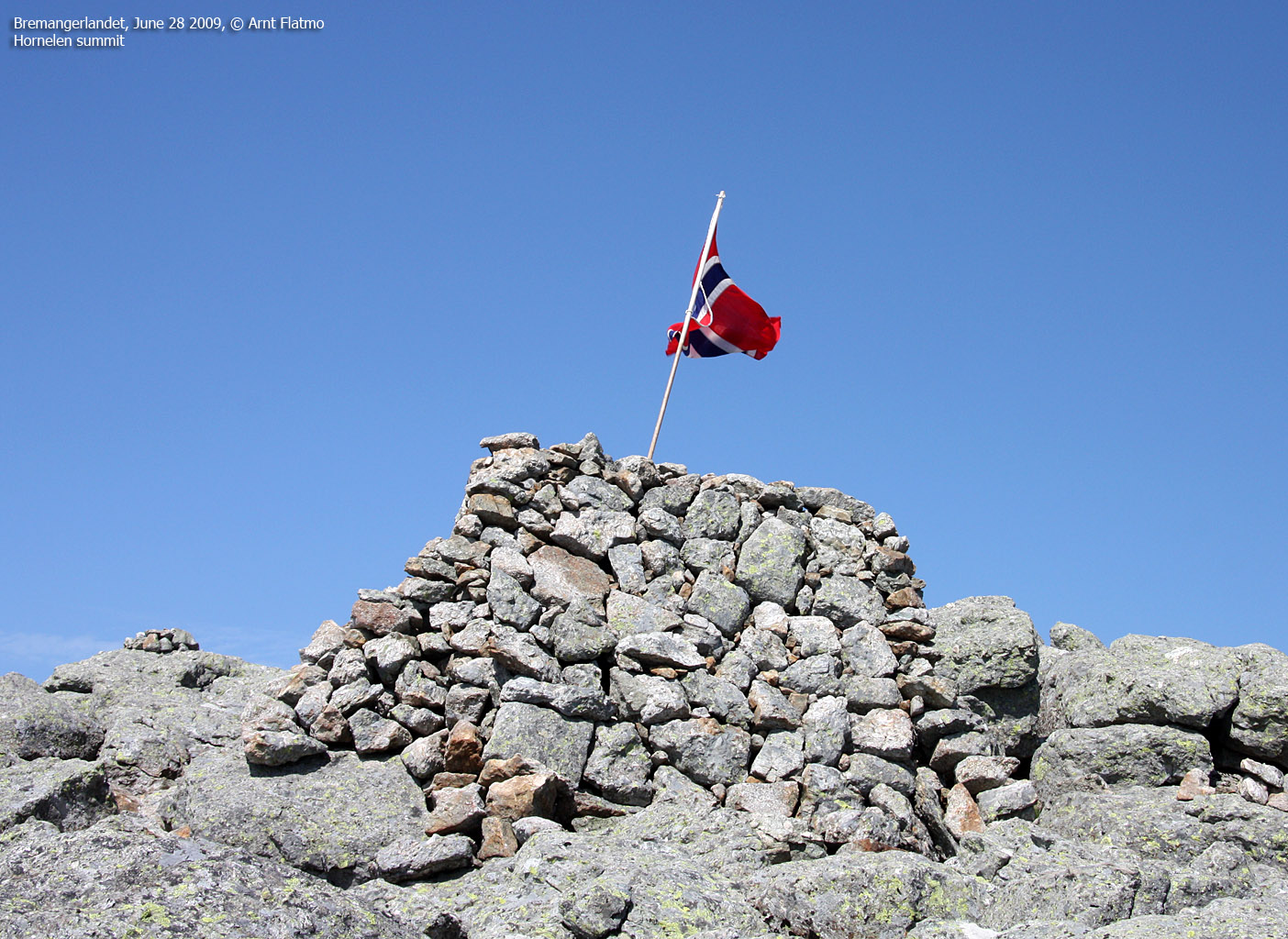
Hornelen has two tops. The main summit (860m) has a shelter on top. The north top (approx. 855m) is found 140m northeast of the summit. The big wall is below the north top.

The north top
(Click for larger image)
Characteristic Norwegian mountains often have legends associated with them. Hornelen is no exception. One of these legends claims that Olav Trygvasson (Norwegian king 995-1000) climbed the steep wall of Hornelen (known as Smalsarhorn at the time) and placed his shield in it. Modern Norwegian climbing history does not seem to recognize Olav's climb as the first ascent, and the honour goes to Kristian Bing - a famous Norwegian climber - for his climb up the east wall in 1897.
Apparently, a troll lives up in the northeast corner of the steep wall. This corner is known as Juratinden among the locals. More legends can be found here (External link - Norwegian text). You may also see "Mona Lisa" and a man with a curvy nose, overlooking the fjord...

View from the north top
(Click for larger image)
| Pioneer climbers such as Kristian Bing did
not benefit from modern climbing equipment and practices, and some of
the stories told by these pioneers are almost "unbelievable" by
today's standards and measures. However, they are highly entertaining. To the right is an excerpt from Kristian Bings notes after having climbed Hornelen's east wall - published by Florø Klatreklubb. The title of the report is "HORNELEN - I BINGS FOTSPOR" - entertaining reading material for those who can read Norwegian. The report can be found here (External link) |
|

Hornelen and Svartevassegga
(Click for larger image)
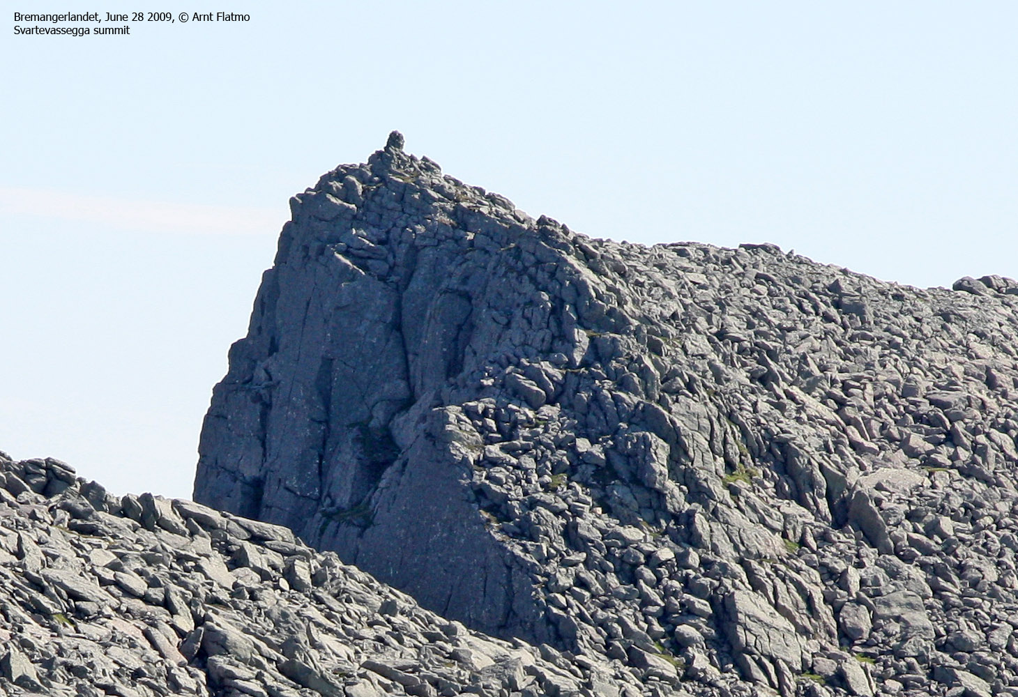
Svartevassegga (Norge 1:50,000: 889m, Økonomisk Kartverk: 889,25m, UTM 32 V 301337 6863914) has a primary factor of 889m being the highest point on the Bremangerlandet island.
GPS measurement read 896m (on the cairn, ~1,5m high), averaged over a 5-minute period (error margin not recorded)
Hornelen (Norge 1:50,000: 860m, Økonomisk Kartverk: -, UTM 32 V 302574 6863825) has a primary factor of 110m towards the higher parent Svartevassegga (889m). The defining saddle (approx. UTM 32 V 302083 6864039) is found between these two tops. Ref. Norge 1:50,000 (20m contours), the saddle is within the range 740-760m, interpolated to 750m.
GPS measurement read 864m (on the ground), averaged over a 5-minute period (error margin not recorded).
Slettheia (name not found on maps) (Norge 1:50,000: Highest contour is 840m, Økonomisk Kartverk: -, UTM 32 V 300414 6863754) has a primary factor of 51m towards the higher parent Svartevasegga (889m). The defining saddle (approx. UTM 32 V 300692 6863873) is found between these two tops. Ref. Norge 1:50,000 (20m contours), the saddle is within the range 780-800m, interpolated to 790m.
GPS measurement read 842m (on the cairn), averaged over a 5-minute period (error margin not recorded). One may consider Slettheia to be a part of Svartvassegga (the Svartvassegga map name is placed above this top, but according to people who know this mountain, the name Slettheia is used for this part of Svartevassegga.
Uraheia (Norge 1:50,000: 848m, Økonomisk Kartverk: -, UTM 32 V 301192 6863143) has a primary factor of 28m towards the higher parent Svartevasegga (889m). The defining saddle (approx. UTM 32 V 301345 6863257) is found between these two tops. Ref. Norge 1:50,000 (20m contours), the saddle is within the range 780-800m, interpolated to 790m.
GPS measurement read 813m (on the ground), averaged over a 2-minute period (error margin not recorded).

Dramatic landscape
(Click for larger image)
Google's interactive map. You can zoom, pan and click on the markers.
|
|
|
|
Route 1: Hunskår/Hornskår - Hornelen (summer/autumn)
|
|
Access
(all distances are approx. distances)
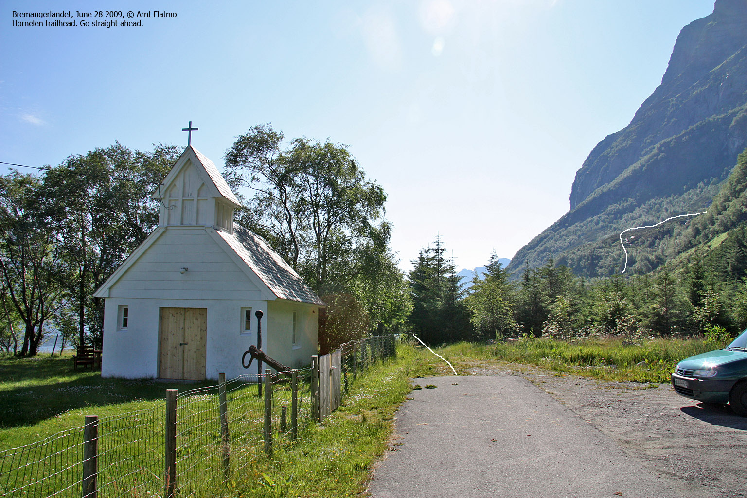
The nearest bigger city is Måløy. From Måløy, take the ferry to Oldeide. At Oldeide, turn left at the first junction, turn left again at the second junction (500m) and drive along the fjord until the road ends at Hunskår/Hornskår (approx. 7,6km). Find parking close to a chapel.
The route
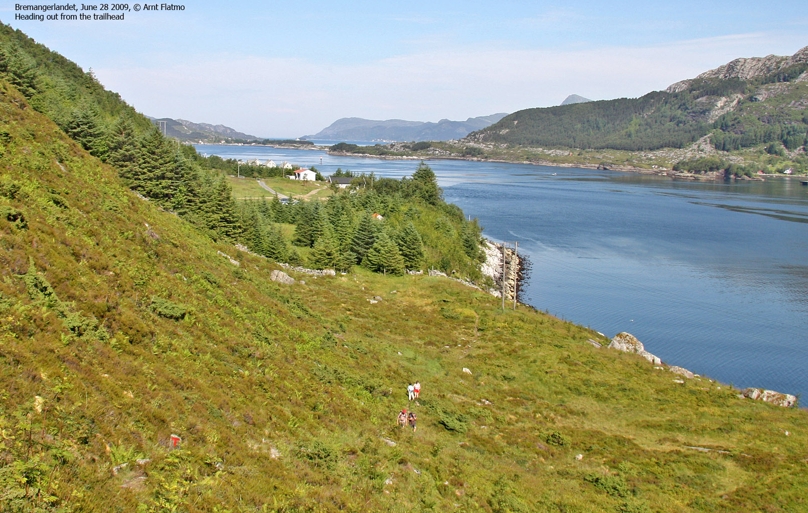
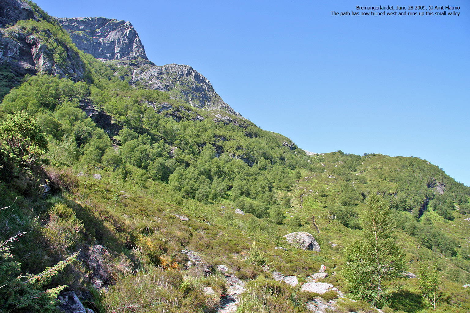
The path is marked by "T"'s, painted on rocks in red. The path starts off in a southeast direction, but after 500-600 metres, the direction changes to the west. You cross a number of streams, and the vertical gain is gradual (as opposed to intense).
Close to Nonsnakken, the path turns south and you pass a couple of lakes that offer fresh water. Next follows a steeper section until you reach the pass between Slettheia (right) and Svartevassegga (left). You will now cross a big plateau (1km of walking) before you descend into the valley between Svartevassegga and Hornelen. The path does not run directly towards Hornelen, but takes a detour to the north before it turns south - towards the summit.
On the summit, you will find a small shelter. The highest point is a few meters away from the cairn. Also visit the north top (N61.85683 E5.24863, approx. 855m) - 140m northeast of the main summit. This is where the interesting views are..

View from the north top
(Click for larger image)
Once up here, you also have the option to visit some of the other tops. You should at least visit Svartevassegga, the highest top on the Bremangerlandet island. If you decide to visit this top on your way back from Hornelen, turn right once you've ascended from the valley between Svartevassegga and Hornelen - and up to the plateau. Svartevassegga summit is just a 650m walk away from this point. From Svartevassegga - proceed west (approx. 750m) to the point where you arrived on the plateau. See the trip report for more information about the other surrounding tops.
 westcoastpeaks.com
Other
Sogn og Fjordane mountains
Other Norwegian mountains
westcoastpeaks.com
Other
Sogn og Fjordane mountains
Other Norwegian mountains


