
Norwegian Mountains, Møre og RomsdalHøgehornet, 1040m
|
| Fylke/Kommune : | Møre og Romsdal/Ørsta | ||||||||||
| Maps : | 1219-IV Sykkylven (Statens Kartverk, Norge 1:50 000) | ||||||||||
| Primary factor : |
Høgehornet: 150m Point 968m: 68m Point 967m: 67m |
||||||||||
| Hiked : | July 2008 | ||||||||||
| See also : |
| ||||||||||
| See also : | Other Ørsta mountains |
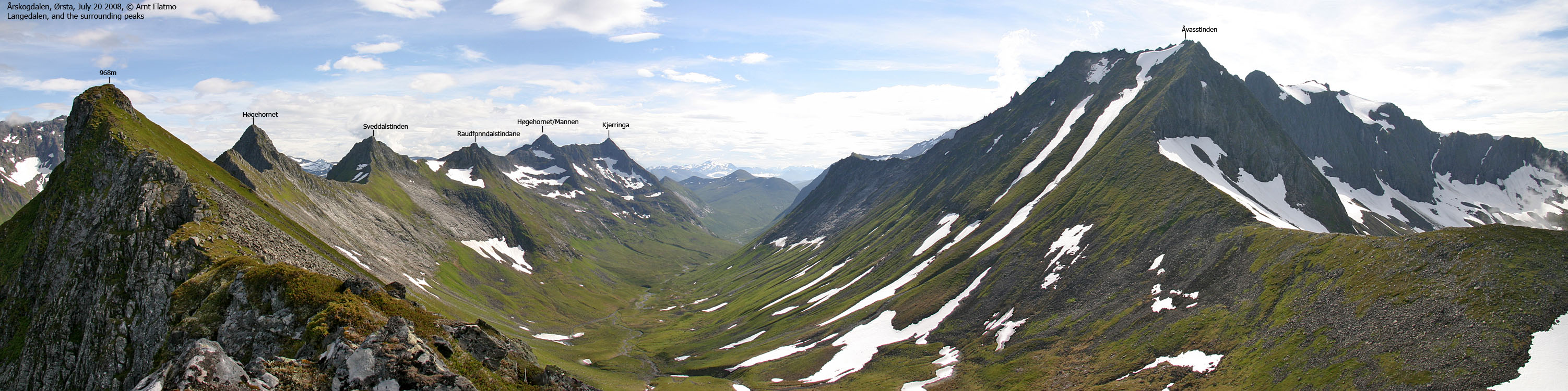
The Langedalen peaks
(Click for larger image)
Høgehornet is the northernmost of the prominent tops on the mountain range between Langedalen and Romedalen valleys. The traverse across this range is known as Romedalstraversen, and is considered by many to be one of the finest traverses in the Sunnmøre region. This Høgehornet (1040m) must not be confused with Høgehornet (1133m), found in the same mountain range. The 1133m peak is also referred to as Mannen.
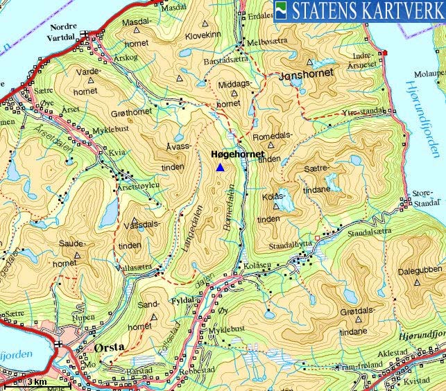
The route to Høgehornet (1040m) begins at Skjerva, where Årskogdalen and Romedalen valleys meet. Both Vartdalsætra/Høgebakken (Årskogdalen) and Steinstøylen (Romedalen) are good trailheads. This page will describe the route from Vartdalsætra/Høgebakken. This is also a good starting point for Åvasstinden, Middagshornet and Masdalhornet.
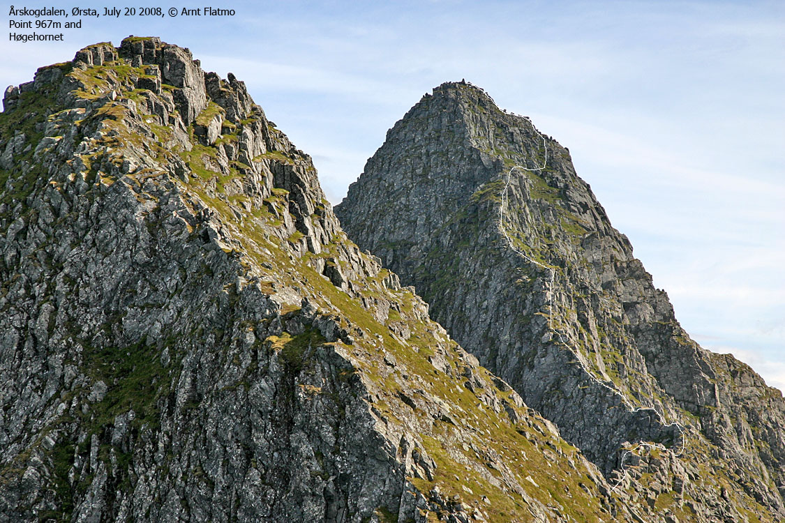
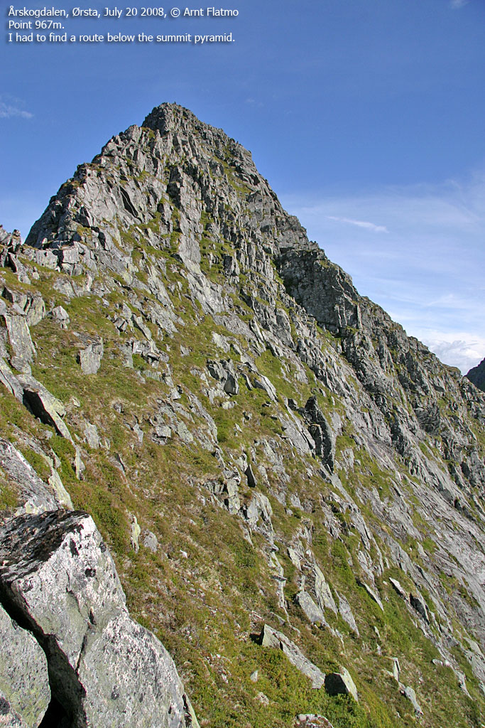
Once on the ridge proper, the route gradually becomes more airy and exposed. You'll pass (or bypass) two unnamed points (968m and 967m) before the summit block rises steep above you. The entire scrambling route is YDS class 3 (easy scrambling), except for one point, which drives the grade up to YDS 4. This point is a 4-meter high block that you need to climb down from, in order to proceed. Those with a low tolerance for exposure will not enjoy this mountain.
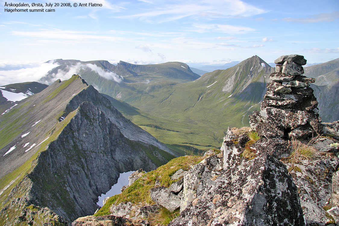
Høgehornet summit
(Click for larger image)
In addition to a fun hike/scramble, the view from the summit is quite spectacular. Just across Romedalen, to the east, you can study the amazing Kolåstinden - Romedalstinden - Middagshornet - Masdalhornet mountain range. To the west, the huge Åvasstinden massif dominates, while Vassdalstinden and Saudehornet stand out in the southwest.
Høgehornet (Norge 1:50,000: 1040m, Økonomisk Kartverk (ØK): -, UTM 32 V 357874 6907640) has a primary factor of 150m towards the higher parent mountain Sveddalstinden (1042m). The defining saddle (approx. UTM 32 V 357743 6907355) is found between the two peaks. Ref. Norge 1:50,000 (20m contours), the saddle is within the range 880-900m, interpolated to 890m.
GPS measurement on the summit cairn (1m high) read 1042m, averaged over a 10-minute period (error margin not recorded).
Point 968m (Norge 1:50,000: 968m, Økonomisk Kartverk (ØK): 968m, UTM 32 V 357367 6908583) has a primary factor of 68m towards the higher parent mountain Høgehornet (1040m). The defining saddle (approx. UTM 32 V 357566 6908121) is found between points 968m and 967m. Ref. Norge 1:50,000 (20m contours), the saddle is within the range 880-900m, and would normally have been interpolated to 890m. But based on the track log, the saddle has been defined as 900m.
GPS measurement on the ground read 970m, averaged over a 2-minute period (error margin not recorded).
Point 967m (Norge 1:50,000: 968m, Økonomisk Kartverk (ØK): 967m, UTM 32 V 357682 6908020) has a primary factor of 37m towards the higher parent mountain Høgehornet (1040m). The defining saddle (approx. UTM 32 V 357688 6907902) is found between the two tops. Ref. Norge 1:50,000 (20m contours), the saddle is within the range 920-940m, interpolated to 930m, which is fairly consistent with the GPS track log.
GPS measurement on the ground read 964m, averaged over a 2-minute period (error margin not recorded).
Google's interactive map. You can zoom, pan and click on the markers.
|
|
|
|
Route 1: Vartdalsætra/Høgebakken - Høgehornet (summer)
|
|

The route
(Click for larger image)
Access
(all distances are approx. distances)
The nearest larger city is Ålesund. From Ålesund, follow highway E39 towards Bergen/Volda to the ferry at Solavågen. Take the ferry over to Festøya. Turn right in the direction of Volda and follow the road 12Km to Nordre-Vartdal. Turn left (signed "Årskog"), then turn left and cross a bridge. After 1,7Km (from E39), pay toll at a self-served toll booth. The fee for passenger cars per June 2008 was NOK 20,-. Proceed to road end at Vartdalsætra/Høgebakken, 4,5Km from E39. The road is gravel and bumpy from 1,6Km to 4,5Km.
The route

The route profile
(Click for larger image)
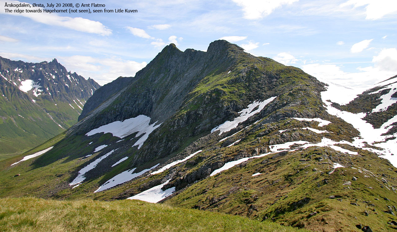
Follow the trail towards Romedalen approx. 650m. Before you reach Skjerva, turn right and hike off-trail in the direction of the stream between Store and Litle Kuven. Locate a path that runs on the east side of the stream. In the valley between Store and Litle Kuven, turn left and gain the ridge between Litle Kuven and the ridge towards Høgehornet. Alternatively, continue towards Ørstaskaret and gain the ridge from there.
Once on the ridge proper, stay on top of it or seek easier ground down to your right. You'll pass a small top (marked as a 920m contour on the map) before reaching a twin-summit top. The eastern top is point 968m. From here, you have a good view towards the ridge ahead.
Proceed towards point 967m, a distinct top just before Høgehornet. Standing on this top, if you consider the descent to be too exposed, then backtrack 100m and pass the top on the south side. You have to actively seek the route, as it isn't totally obvious. Follow natural ledges and stay as high as you can.
Follow the ridge towards Høgehornet until you run into the "crux" - a 4-meter high block that you will need climb down. Once down, traverse on grass to the southwest ridge and find a good scrambling route to the top (hint: seeking right may result in an easier scramble, but the exposure is greater).
A small cairn marks the summit of Høgehornet. Congratulations are in order. Descend your ascent route.
 westcoastpeaks.com
Other Møre & Romsdal mountains
Other Norwegian mountains
westcoastpeaks.com
Other Møre & Romsdal mountains
Other Norwegian mountains


