
For Information, maps, trailhead and route descriptions, click HERE.
It was day five..
.. of our holiday week in northern Norway. Prior to arriving Harstad, Torill and I had spent 3 days in the Kjøpsvik area, climbed Stetind as part of a guided group, and hiked Stefjordnestinden and Mulbukttinden. The day before, we visited Sætertinden, the highest top in Harstad and Tjeldsund kommuner.
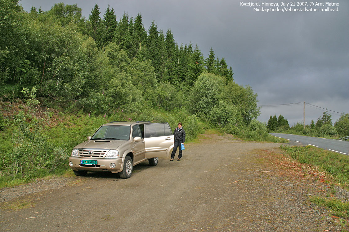
Our primary goal, Nona (1012m) on Grytøya, was not on the agenda for this Saturday. It was raining and the clouds hung low down on Grytøya. Torill had granted me the authority to pick the mountains, and it didn't take much planning to conclude that Middagstinden was a good candidate. The peak was fairly close to Harstad, The distance to the top was acceptable, ditto the elevation, and besides, the narrow ridge looked interesting on the map. The only info I found on the net, was that die-hard skiers ski the eastern couloirs and that hikers hike from the east. Our route would be from northwest, which meant we didn't know if there would be any obstacles. And that's always an interesting start to a hike, isn't it?
Middagstinden
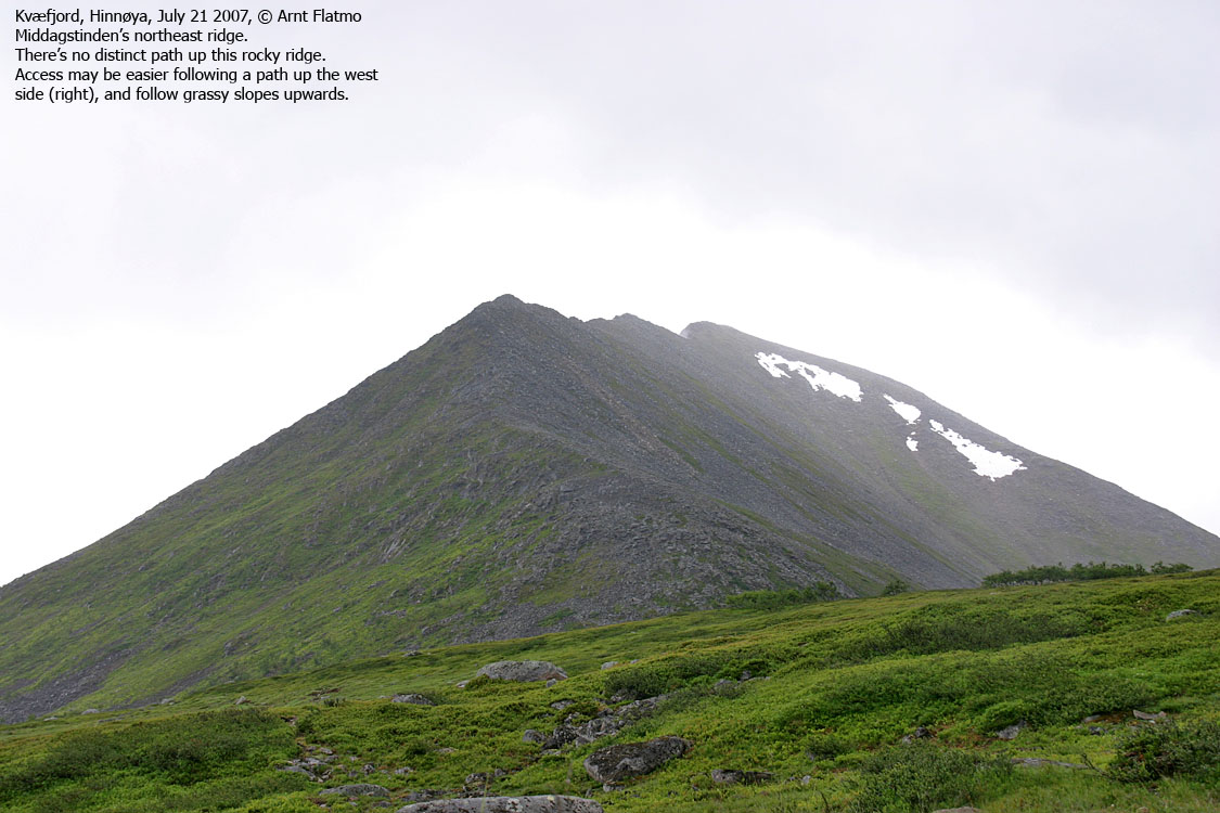
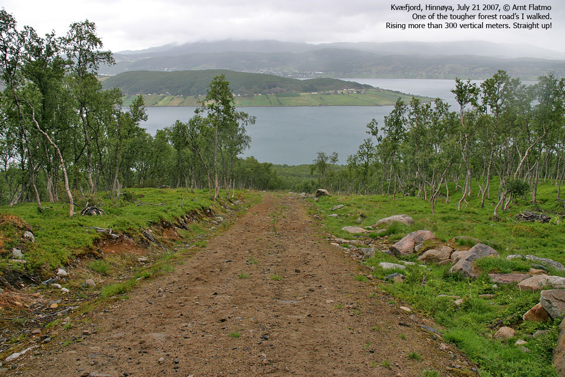
We left the trailhead 09:15PM, and besides a really long forest road, Middagstinden hadn't any fun obstacles in store for us. True, the northwest was somewhat steep, rocky and slippery, but after having been on Stetind, we didn't consider that hard. It was raining light, but fortunately, Tverrfjellet and Horntindan did their best to rip apart the fog that came from the southwest.
To get at least a minimum amount of fun out of the hike, I explained to Torill that we had to scramble the ridge crest. Applying female logic, she must have wondered why we didn't just walk on the south side of the ridge crest. Far easier, and no exposure. But I had the good exercise argument up my sleeve, and that wins every time...
I knew I was pushing my luck when I argued that walking with one foot on either side of the ridge was cow style. It would be far more graceful if one walked on the side of the crest (preferably on the steep side, but I left it optional), with hands on top. But I got away with that too.
And then we stood on Middagstinden summit, 11:10AM, a bit wet and with no views to show for. Still, it was a good morning workout and this was a good place to be. Those buggers at the bar below the hotel, bugging me half the night, would still be asleep by now. Not getting fine moments such as this - being 830Km away from home, on a splendid mountain, without seeing a damned thing.
Descent
We considered a roundtrip hike, either via Langdalen or Salvatnet, but agreed to descend our ascent route. As we left the summit, I wasn't aware of how little Torill looked forward to the rocky ridge, until later. And it surely couldn't have helped much when I announced that now, we're really gonna scramble this ridge.
Then Torill found this convenient grassy slope that would take us all the way down to Lake Vebbestadvatnet. At first, I thought she was joking. What, trade this coool, slippery, partly exposed, rocky ridge for that grass? She wasn't joking, and I had to catch up, wondering what had happened to my influental capabilities.
Gradually, I had to admit that the grassy slope was quite convenient. After a while, we even came across a path, and the descent became a doddle. We were back at the trailhead 12:50PM, with ample time for rest and nerd stuff on the computer before dinner and beer in the evening. Another fine day in northern Norway.
The next day was the last day of the holiday. We hiked Hinnstein (560m) and Vardheia (604m) in the morning, and then, with extended check-out time from the hotel, Elgen (534m) on Elgsneshalvøya.
To Middagstinden


Descent


No Javascript:
1 2 3 4 5 6 7 8 9 10 11 12 13 14 15 16 17 18 19 20 21
