
|


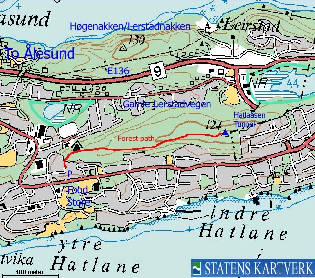
Hatlaåsen is one of two forest hills between Nørvøya (Ålesund) and Spjelkavik. Høgenakken/Lerstadnakken being the other. These forest hills offer some good, sheltered walks in the middle of the crowded Ålesund - Spjelkavik region. The forest hills are close neighbours, with "Gamle Lerstadvegen" running in-between. Many chose to visit both hills on the same walk.
The high point (124m) is not marked (as far as I can tell) and there are trees blocking the views. But 130m to the west, and along the route described on this web-page, the views are excellent.
Hatlaåsen (Norge 1:50,000: 124m, Økonomisk Kartverk: 123.90m, UTM 32 V 360327 6928864) has a primary factor of 71m towards the higher parent mountain Høgenakken (130m). The defining saddle (approx. UTM 32 V 359871 6929317) is found along E136 between the two tops. Ref. Økonomisk Kartverk (5m contours), the saddle is within the contours 50-55m, interpolated to 53m.
Notes: Class ratings are in reference to YDS. Click here for more information.
The trails described below are not necessarily the *easiest* trails to this mountain.
|
Vestre Hatlaåsen- Hatlaåsen (all seasons)
|
|
Access
From Ålesund, follow highway E39/E136 and exit towards "Gåseid" soon after leaving Nørvøya island. After (ROUGHLY) 2,2Km you reach a 4-way junction with a traffic light. There is a food store on your right-hand side ("Meny" per Jan. 2006). Turn left in this junction, and turn right at the next junction. Find parking alongside the road, somewhere.
The route
Head up the first road on the right-hand side (coming from the 4-way junction). After 120m, you will see the sign "Gangveg til Hatlaåsen". The path begins here and takes you all the way across the ridge. In the beginning, your view is towards the north. This shifts after a while and your view is south until you reach 120m elevation, where you have view in all directions. The top of the forest ridge is 130m further east.

No Javascript:
 westcoastpeaks.com
Other Møre & Romsdal mountains
Other Norwegian mountains
westcoastpeaks.com
Other Møre & Romsdal mountains
Other Norwegian mountains

