
|

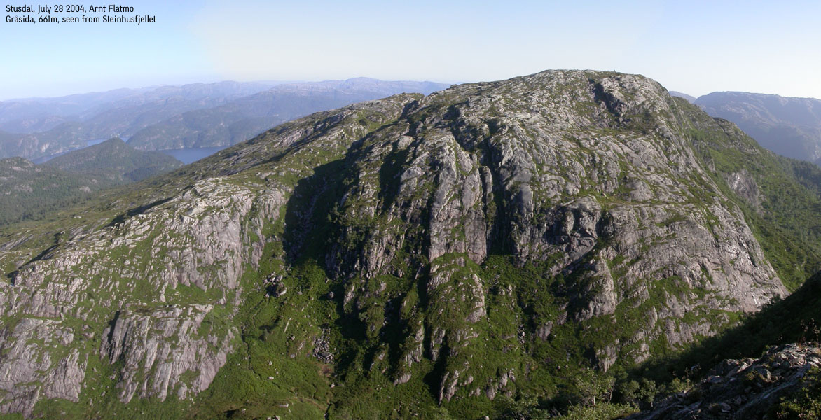
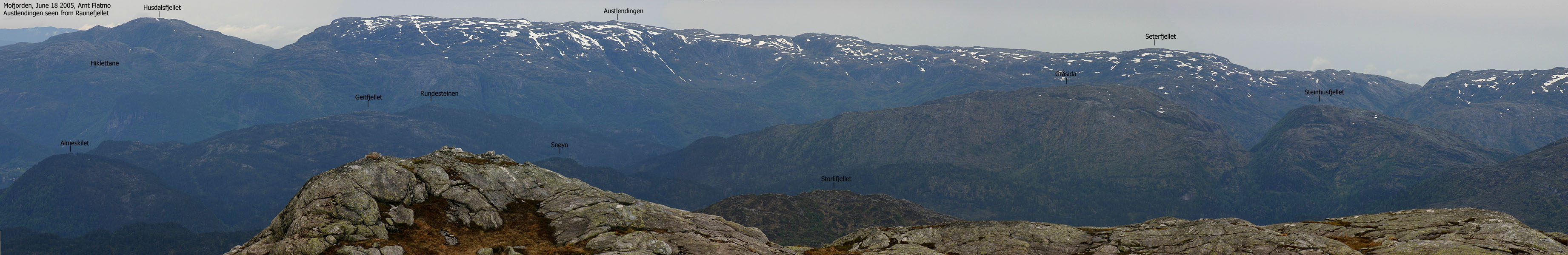
Graasida seen from Steinhusfjellet(No Javascript) |
Gråsida (Grey side) is one of the many mountains between highway E39 (Bergen and Sognefjorden) and the west coast. The area can be thought of as the southern Masfjorden/Matre mountains, although the mountain lies within Lindås kommune. The summit provides good views to the nearby mountains, but through the mountains low height and primary factor, it is far from being the best viewpoint in the area.
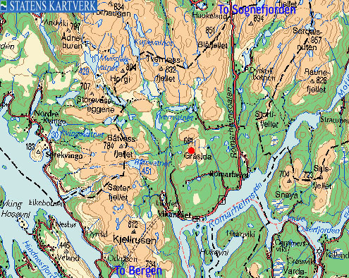
Gråsida is easiest reached from the Stussdalen or Aurdalen valleys. The Aurdalen approach is described in this document. Refer to Stussfjellet for more information about Stussdalen. Gråsida has Steinhusfjellet as a close neighbour, giving the possibility for two summits on a day hike. The Steinhusfjellet hike is not described on this page.
Snøyo is a viewpoint SW of Gråsida. The map states that the Snøyo height is 513m, but the correct height is closer to 570m. Snøyo is an interesting pyramid-shaped peak lacking enough primary factor to be considered as an independent peak.
Primary factor:
Gråsida primary factor of 308m towards the higher Stussfjellet. The high route to runs over Steinhusfjellet and the saddle is found S of lake øvre Tverrvatnet. The saddle height is interpolated to 353m.
Note: Class ratings are in reference to YDS (Yosemite Decimal System).
Note: The trail described below is not necessarily the easiest trail to this mountain.
|
Aurdalen - Gråsida (all seasons)
|
|
Access
From Bergen, follow highway E39 towards Førde. Pass the toll station on Nordhordlandsbrua (fee for passenger car per Dec 2003 is NOK 45,-) and continue 32,5 Km northbound. Turn left onto an unmarked road just before the 2nd tunnel after you have left the long Eikefet tunnel.
The intervals from Nordhordlandsbrua are:
| Nordhordlansbrua Toll Station | 0Km |
| Shell Knarvik | 2,8Km |
| Leknes exit | 8,1Km |
| Eknes/Hindenes exit | 16,7Km |
| Ostereidet exit | 21Km |
| Masfjordnes exit | 26,1Km |
| Eikemo exit | 31,4Km |
| Aurdalen exit (unsigned) | 32,5Km |
Once you exit, there is one road going off to the right. Another road goes off to the right just a few meters further ahead. Take the 2nd exit. The 1st exit is made by a construction company that performs demolition activies near Husafjellet. A sign - "Sprenging pågår" pretty much tells you not to drive up exit #1.
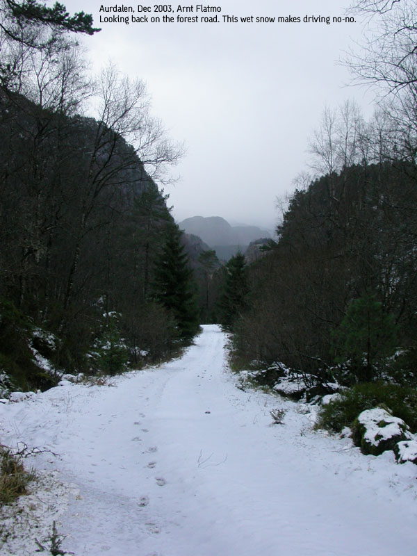
From exit #2, follow a paved road up to the nearest buildings. On the left hand side of a red barn, the Aurdalen forest road begins, and runs upwards for 3,6Km. This is a private road, so you should ask for permission at the nearest houses if you want to drive up the road. Note that the road is low-clearance at times.
If the season allows you to drive all the way, then note this: Shortly after you leave the houses, you join the construction road that started at exit #1. After a short while, the road forks. The construction road runs straight ahead, but is probably blocked by a gate with a warning board. Turn right and follow the gravel road until it ends.
This information is valid per December 2003. The forest road up Aurdalen valley allows for parking here and there alongside the road.
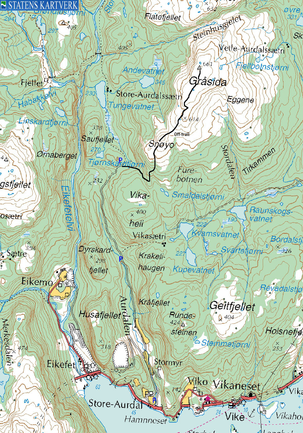
The route
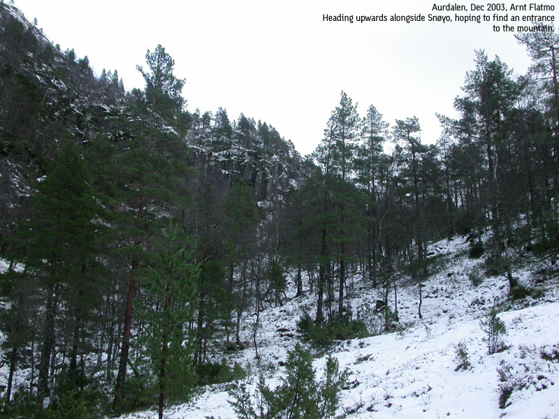
If you were unable to drive all the way to road end, then walk the road until road end. There you will have the SW face of Snøyo in front of you. Leave the road and walk alongside the Snøyo walls until you are between Snøyo and Vikaheii at approx. 380m. Turn north, slightly northeast and locate a distinct gully that takes you to a viewpoint just below Snøyo.
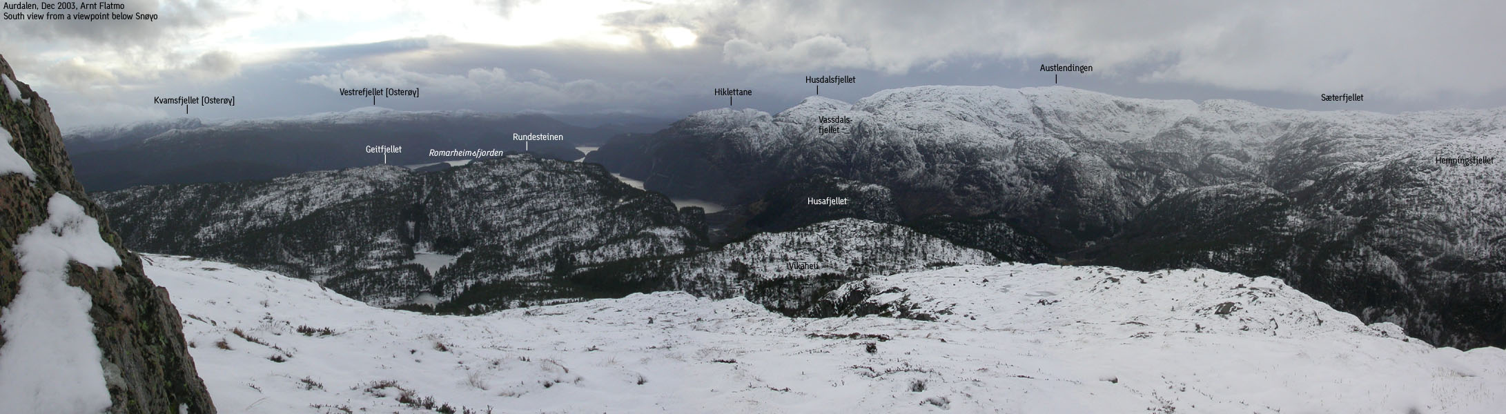
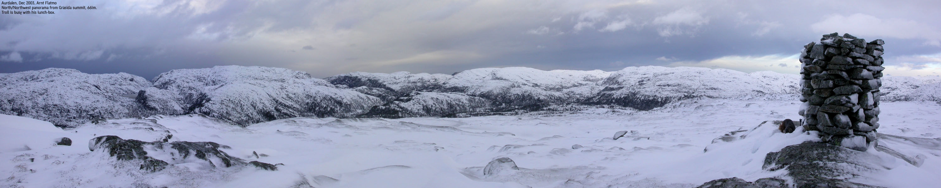
Continue over Snøyo. You can traverse this top slightly to the right of its summit. From Snøyo, you see the Gråsida summit plateau, and you see two high points. There is a high ridge between the two high points, which makes this view an illusion. Set course for the leftmost high point. Once up there, you will see the real summit, which is 10-15 minutes further northeast. The summit is marked by a proper cairn. Descend your ascent route.
It was a lucky day. The weather in Bergen was bad, but now and then, blue sky could be seen. The forecast promised nothing but rain. Further north, the sky looked grey and miserable. I had the option of a potential hike in severe weather further north or do a familiar hike in Byfjellene near Bergen. I had a strong desire to visit a new mountain and decided to head north. It was raining heavily, and I expected the hike to be one of those you soon forget about.
But the weather was holding up the further north I came. The clouds turned everything into shades of grey, but this was clearly a bonus. I found the start of the Aurdalen forest road, and rang the doorbell at the nearest house. The owner suggested where I should ascend Gråsida, which was in line with my own plans. He told me the road was low-clearance, but if I took it easy, I should be OK.
On the level road into Aurdalen I suddenly ran into wet and slippery snow just before the road started to descend. I made a few attempts to drive up the hill, but this soon proved to be a bad idea. I had to drive in reverse 400m before I could turn the car around. Then I drove in reverse back to the start of the hill. At that very moment, I wanted the car to point the right way when the hike was over. As the forecast suggested snow, then there's no harm in being prepared.
I left the car 11:30AM, and the road didn't seem to end. But eventually, we reached the road high point, and it was fairly obvious that I had to walk along the Snøyo cliffs in order to find a place to ascend the mountain. After a while, I found a gully which took me to a viewpoint I mistook for being Snøyo. Ahead of me was a distinct peak which I believed to be the lower section of Gråsida. After the hike I discovered that this was Snøyo, but the map height was off by approx. 60m!
From Snøyo, I had to descend some in order to get onto the Gråsida hills. There were a couple of humps along the way, and I noticed that every pass was blocked by a low stone fence towards the north. I pondered about this for a while without reaching any conclusion. On the top of the next hill, I finally saw the summit cairn on Gråsida, 10-15 minutes away. The backpack load was heavy, as I had carried the dog all the way. Adding the snow, I named the summit "Disappointment Peak", as I never seemed to get there.
I reached the summit 13:30PM sharp, and sinister winds were raging on the plateau. Taking pictures without gloves was quite unpleasant. Troll was shivering while eating his lunch-box. He developed an icy fur in an instant as the winds were moving the snow across the plateau. Still, we were quite fortunate as we had views all the way. The clouds were high on the sky, and the snow/rain that was passing was passing south of our location. I let Troll walk down. He was in a hurry to get off this mountain and wasn't difficult when I told him we were leaving. Snow, strictly too deep for a small dachshund, was ignored with a strong determination to get back to the car. We were back at the car 14:35PM, close to an hour after leaving the summit.
Move cursor to read notes, and click on the images to see full version.
Some of the thumbnails may have been cropped to fit the format.
Pictures are presented in the order they were taken.


No Javascript:
1 2 3 4 5 6 7 8 9 10 11 12 13 14 15 16 17 18 19


No Javascript:
 Other hordaland mountains
Other Lindås K. mountains
westcoastpeaks.com
Other hordaland mountains
Other Lindås K. mountains
westcoastpeaks.com

