
Norwegian Mountains, Møre og Romsdal
Gjuratinden, 1712m
Hoemskardtinden, 1430m
| County/Municipality: | Møre og Romsdal county/Rauma & Nesset municipality | ||||||||||
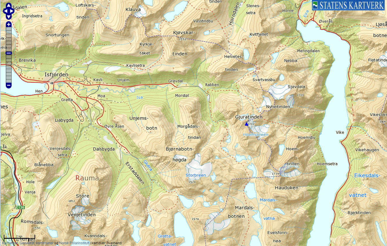
| Maps: | 1320-II Eresfjord (Statens Kartverk, Norge 1:50 000) | ||||||||||
| Primary factor: |
Gjuratinden: 278m Hoemskardtinden: 120m | ||||||||||
| Hiked: | May 2012 | ||||||||||
| See also: |
| ||||||||||
| See also : | Other Møre og Romsdal mountains on westcoastpeaks.com |

Gjuratinden
(Click for larger image)
Introduction
Gjuratinden (aka Gjuratind, Juratinden, Juratind) is without a doubt one of the most spectacular peaks in the mountain region around Isfjorden. The peak has two summits - and from a distance, the two summits may resemble two udders (pointing in the opposite direction...). The western summit (1712m) is the highest of the two.
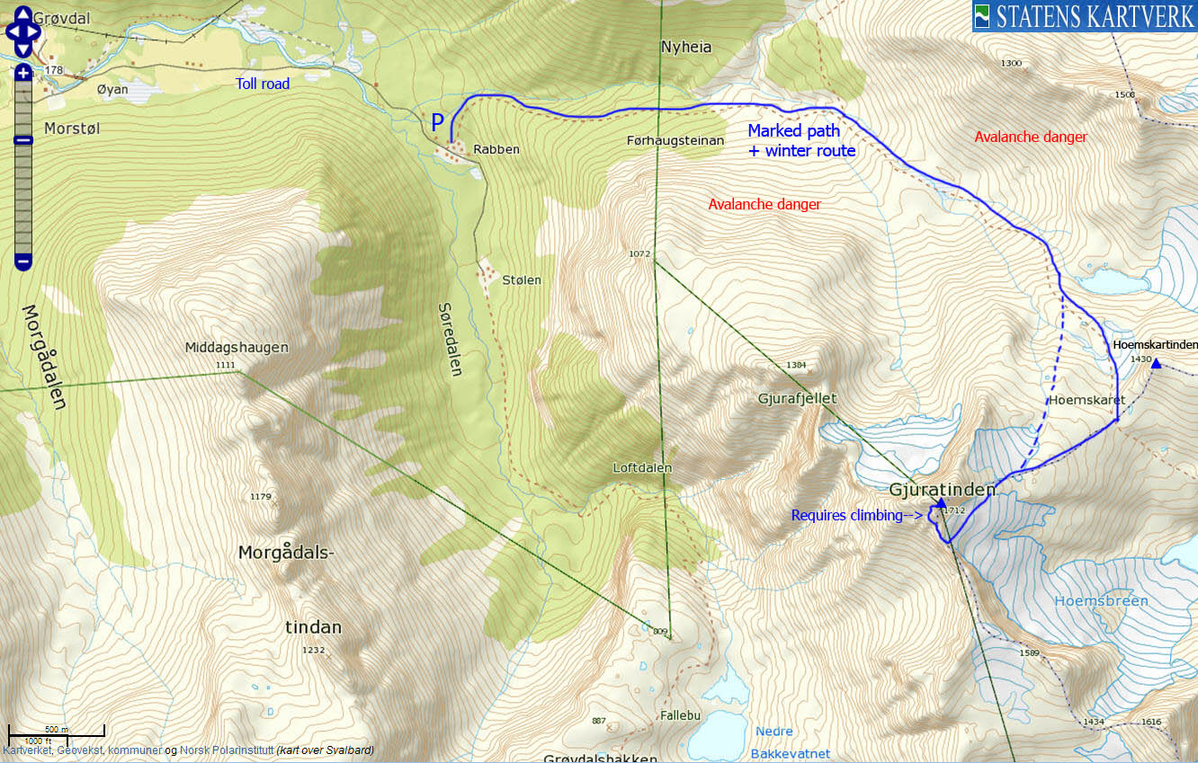
The mountain is normally visited in spring - on skis. The usual starting point is Rabben sæter in Grøvdalen by Isfjorden and the route upwards offers a variety of exciting ingredients, ranging from potential avalanche danger, glacier crossing, cornices, steep couloirs (gullies), scrambling and climbing. Sounds dramatic, you say? Well, don't be discouraged just yet. This is actually quite a popular mountain although there is a small climbing pitch (requires a rope for safety) just below the summit. That said - the route calls for experienced visitors. Read on for more detailed information about the route.
Note that there are guided tours to Gjuratinden. Refer to Norsk Fjellfestival for more information.
There is also a route from Hoemsbu by Eikesdalsvatnet - joining the Rabben route near Hoemskaret, but you can't get to Hoemsbu by car.
Hoemskardtinden is an easy top that you pass on your way to or from Gjuratinden. The name is not found on any maps, but has been brought through the grapewine. You have a tremendous view towards Gjuratinden from here. See the below picture...

Gjuratinden seen from Hoemskardtinden
(Click for larger image)
Primary factor:
Gjuratinden (Norge 1:50,000: 1712m, Økonomisk Kartverk: -, UTM 32 V 451024 6937738) has a primary factor of 278m towards the higher parent mountain Hauduken (1734m). The defining saddle (approx. 32 V 452038 6936614) is found between point 1589m and point 1615m and is defined as a fixed point - 1434m.
Hoemskardtinden (Norge 1:50,000: 1430m, Økonomisk Kartverk: -, UTM 32 V 452112 6938599) has a primary factor of 120m towards the higher parent mountain Gjuratinden. The defining saddle (approx. 32 V 451920 6938275) is found in Hoemskaret. Ref. Norge 1:50,000 (20m contours), the saddle is within the range 1300-1320m, interpolated to 1310m.

Hoemskardtinden
(Click for larger image)
Google map
Google's interactive map. You can zoom, pan and click on the markers.
|
|
Trail descriptions
| This disclaimer is regarding all of the literature and instructional guides posted on the westcoastpeaks.com website. These instructions are guidelines only, and should not be used in lieu of common sense or judgment when attempting any of the actions involved or instructed. Westcoastpeaks nor myself will not be liable nor will it indemnify any form of compensation to anyone who has injured, harmed or even killed themselves or others while following any of the instructions written within the website. It should be noted by any persons willing to undertake any of the instructions provided that mountains offer varying levels of risk, regardless of size or incline. Risks to be considered are as follows but not limited to: wild animals, weather, the terrain, bad judgment, inappropriate or insufficient equipment, improper training or experience and of course, bad luck... |
|
Route 1: Rabben - Gjuratinden (spring ski-trip)
|
|


This route description is valid per May 2012
Access
(all distances are approx. distances)
The starting point for this route description is Isfjorden - just east of Åndalsnes.
Turn onto the road to Grøvdal (signposted, N62.57705 E7.77583). Follow this road for 1,6km, then turn left at a fork and continue towards Grøvdal (still signposted, N62.57920 E7.80547). Continue 7,8km until you reach the start of the toll road (N62.58316 E7.95340, NOK 30,- per May 2012). Follow this (unpaved) road for 2,2km until you reach Rabben sæter (N62.58175 E7.99211 - 160 meters elev.). There is a path signposted "Hoemsbu" here. This is your trail. Find parking nearby.
The route:

The route, as seen in Google Earth
(Click for larger image)
Follow the "T" marked trail up to the point where you can begin skiing. The valley you're in has avalanche danger from Gjurafjellet. Consider staying closer to the river. As you approach the inner part of the valley, there is also avalanche danger from point 1508m.
Proceed up a steep hill which may be avalanche prone between 800 and 950 meters. Continue in the direction of lake 1096m and turn south in the direction of Hoemsbreen where you see fit. Aim for the ridge between Gjuratinden and point 1589m, and ascend the ridge using a snow ramp. Be aware of a cornice above this ramp. You don't want to be under it when it collapses. Once up on the ridge, continue up the southeast ridge on foot.
The southeast ridge scrambling is easy. After 170 meters, the route turns west (the summer route continues up the ridge but is not covered here). Cross a steep couloir and then scramble over to a second couloir which you follow upwards - in the direction of the summit. You have to consider the risk of avalanches in these couloirs.
 crossing below Gjuratinden")
Couloir (gully) crossing below Gjuratinden
(Click for larger image)
Aim for the traditional belay point on the southwest corner of the summit block - approx. 30 meters below the summit. The scrambling is still easy, but more exposed. Just below the summit, you'll run into the route's hardest point (the crux) - 3+ on the Norwegian scale. Those who are not climbing rock on a regular basis might find this 5 meter high point difficult. The summit (N62.56726 E8.04715) can fit up to 10 people before you really start feeling the constraints of this place...
It is usual practice to take a 50 meter rappel straight down the southwest face of the summit block - into the couloir you ascended. Return your ascent route.
Also consider visiting Hoemskardtinden (1430m) on your way down. This is an easy bonus top.

Rappel from Gjuratinden
(Click for larger image)
Pictures and Trip reports:
- Gjuratinden, May 26 2012
 westcoastpeaks.com
Other Møre og Romsdal mountains
Other Norwegian mountains
westcoastpeaks.com
Other Møre og Romsdal mountains
Other Norwegian mountains