
Norwegian Mountains, Oppland
Formokampen, 1428m
| County/Municipality: | Oppland/Sel municipality | ||||
| Maps: | 1718-IV Otta (Statens Kartverk, Norge 1:50 000) | ||||
| Primary factor: | 298m | ||||
| Hiked: | July 2012 | ||||
| See also: |
| ||||
| See also : | Other Oppland mountains on westcoastpeaks.com |
")
Formokampen (left)
(Click for larger image)
Introduction
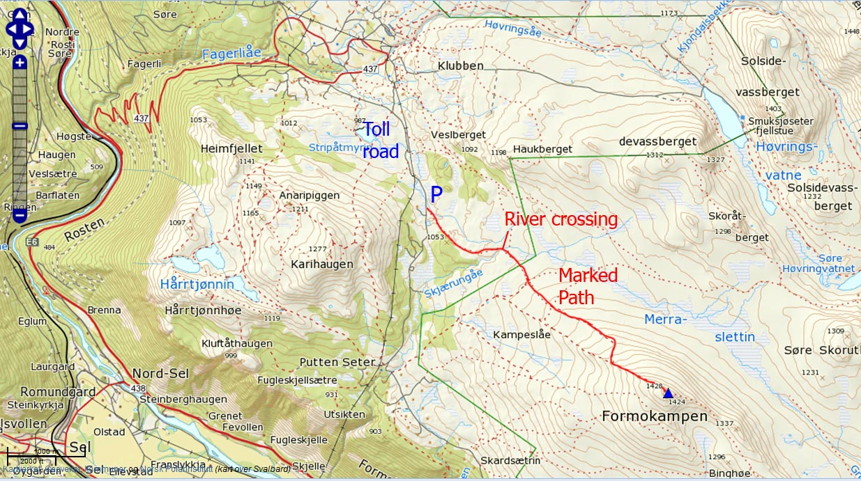
Formokampen is a popular mountain top, located on the western outskirts of Rondane National Park, and easily accessible from the (toll) road to Putten Seter. A well marked and visible trail runs all the way to the top. The only challenge is a river crossing, where the amount of water determines how challenging the crossing will be...
A fast hiker will cover the 4,5km to the top in less than one hour. The average hiker should plan for a little more time spent on the trail.

On the trail to Formokampen
(Click for larger image)
The Høvringen - Rondane region offers a vast number of hiking routes, and accommodation can be found both on Høvringen and down in Otta. If you want to do more tops on your hike, you can also visit Karihaugen (1277m) and/or Baksidevassberget (1327m).

River crossing in July
(Click for larger image)
Primary factor:
Formokampen (Norge 1:50,000: 1428m, Økonomisk Kartverk: -, UTM 32 V 529553 6858031) has a primary factor of 298m towards the higher mountains to the east. The defining saddle (approx. 32 V 530863 6860405) is just south of lake 1124m. Ref. Norge 1:50,000 (20m contours), the saddle is within the range 1120-1140m, interpolated to 1130m.

Formokampen summit cairn
(Click for larger image)
Google map
Google's interactive map. You can zoom, pan and click on the markers.
|
|
Trail descriptions
| This disclaimer is regarding all of the literature and instructional guides posted on the westcoastpeaks.com website. These instructions are guidelines only, and should not be used in lieu of common sense or judgment when attempting any of the actions involved or instructed. Westcoastpeaks nor myself will not be liable nor will it indemnify any form of compensation to anyone who has injured, harmed or even killed themselves or others while following any of the instructions written within the website. It should be noted by any persons willing to undertake any of the instructions provided that mountains offer varying levels of risk, regardless of size or incline. Risks to be considered are as follows but not limited to: wild animals, weather, the terrain, bad judgment, inappropriate or insufficient equipment, improper training or experience and of course, bad luck... |
|
Route 1: Puttenvegen - Formokampen (Summer/Autumn)
|
|


This route description is valid per July 2012
Access
(all distances are approx. distances)
The starting point for this route description is the place Otta in Gudbrandsdalen.
Approx. 17km north of Otta, leave highway E6 and turn right onto the road to Høvringen (signposted, N61.87637 E9.42065). Then;
- Follow this road for 5,4km - first up the switchbacks, then into the valley until you reach a fork (N61.88893 E9.45420)
- Turn right
- Drive 0,85km to another fork (N61.88715 E9.46940)
- Turn right towards Putten Seter (signposted). This is an unpaved toll road (NOK 50,- for passenger cars)
- Drive 2,4km until you see the Formokampen signpost on the left-hand side of the road (N61.87325 E9.49799).
- Park alongside the road without blocking for other traffic
The route:

The route, as seen in Google Earth
(Click for larger image)
- Follow the trail for 1,4km south/southeast until you reach a fork (signposted, N61.86954 E9.51965)
- Cross the river
- Continue 0,5km southeast on the path to another fork (signposted, N61.86565 E9.52515)
- Proceed 1,8km up to Formokampen's northwest ridge
- Follow the ridge for 0,8km up to the summit cairn (N61.85389 E9.56156)

On top of Formokampen
(Click for larger image)
 westcoastpeaks.com
Other Oppland mountains
Other Norwegian mountains
westcoastpeaks.com
Other Oppland mountains
Other Norwegian mountains