
|

Parts of the glacier seen from above |
| The Folgefonna glacier is a majestic landmark in Hordaland, enclosed by the
fjords Hardangerfjorden to the west and Sørfjorden to the east. The
Folgefonna peninsula (Folgefonnhalvøya) connects to mainland between
Odda and Fjæra. The glacier is located quite central in Hordaland Fylke, and can
be seen from most higher mountains in Hordaland.
Folgefonna actually consist of three glaciers; the northern (26 Sq.Km), the middle (11 Sq.Km) and the southern (168 Sq.Km). The southern Folgefonna glacier is a plateau glacier, and is the 3rd largest of all Norwegian glaciers. Due to the large size of Folgefonna S., there are a number of access points for visiting the high point (1662m). The majority of the access points are on the west side. The south and east sides of the glacier are steep and unforgiving. The two most popular routes to the glaciers are from Fonnabu (NW) and Tokeim near Odda (E). The route from Odda/Tokeim is described further down on this page. Skiing across the glacier is a popular activity, and although long, not quite comparable to skiing across Jostedalsbreen glacier, Norway's largest glacier, and almost 3 times larger than Folgefonna. If you are skiing from Holmaskjera to point 1389 near lake Fonnavatnet (en route to Rosendal), then the distance will only be minimum 20Km (less than 200m vertical gain). However, getting to - and from the glacier comes in addition to the actual ski-trip, and is often the most strenuous part.

Folgefonna from the south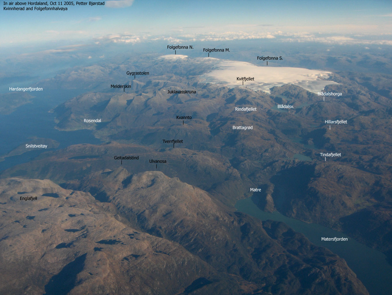
|
|
High Points
Noteable high points on the glaciers are:
Holmaskjera, 1565m. This is the highest solid rock on the glacier, and also the highest solid rock point in Kvinnherad Kommune. The Holmaskjera is however not a separate mountain. There is only a 35m drop between Holmaskjera and the glacier high point. The Kvinnherad/Odda kommune border runs across the Holmaskjera summit.
Folgefonna S, 1662m. This is the highest point on the glacier, and the highest point in Kvinnherad Kommune. Folgefonna S. has also the highest primary factor in Hordaland Fylke (1233m). The Kvinnherad/Odda kommune border runs across the 1662m high point (Odda has higher mountains on the Hardangervidda plateau).
Folgefonna S, 1638m. This point lies further approx. 6Km further SW of 1662m, and has almost no primary factor (re-ascent) towards 1662m. However, 1638m is a three-way Kommune border (Kvinnherad,Etne and Odda). 1638m is the highest point, rock or glacier, in Etne Kommune.
Primary Factor
Folgefonna S. has a primary factor of 1233m towards the higher mountains on the southern Hardangervidda plateau. The high route pass is found near Grøstøl, on the road between Skare and Fjæra. The lowest point on this route is interpolated to 429m.
Holmaskjera has only a primary factor of 35m (as such, not a ranked summit) towards Folgefonna S. 1662m. The saddle is just SW of Holmaskjera, and is interpolated to 1530m.
Note: Class ratings are in reference to YDS (Yosemite Decimal System).
|
Tokeim (Odda) - Holmaskjera (summer/autumn)
|
|
Access
There are several ways to get from Bergen to Odda, which is close to the Holmaskjera trailhead. The ferry from Kvanndal to Utne (or Kinsarvik) has normally been the standard route to Odda, but since the tunnel under Folgefonna opened, the following route can be considered:
From Bergen, follow E16 towards Oslo. Exit onto highway 7 at Trengereid. Then exit onto highway 48 (Tysse) just after Bjørkheim. Pass Tysse and drive to Eikelandsosen. When this was written, there was lengthy and major roadwork on the Mundheim - Gjermundshamn. If you see a sign at Eikelandsosen about this stretch, then you have to take a detour via Sævaried. If not, continue to Mundheim, and exit onto highway 49 towards Gjermundhamn.
Take the ferry from Gjermundshamn to Løfallstrand, and make sure you get on deck and see the beautiful Rosendal/Uskedalen mountains on your right. From Løfallstrand, go left after the ferry (towards Odda). Drive approx. 25,8Km to the toll booth before the Folgefonna tunnel (11150m long). On the road from the ferry, you will pass Ænes. Look up to your right when you pass the church, and see the magnificient north side of Gygrastolen (1339m).
Pay a fee at the toll booth (Apr 2003: NOK 55,- for passenger cars) and drive through the tunnel. Approx. 11,7Km after the toll booth, you enter a roundabout. Go right and follow the highway towards Odda for approx. 1,4Km. You will see a trail sign towards "Holmaskjera". Exit the highway and drive up the short gravel road to the parking area.
The route
A very nice trail will take you from the parking to Tokeimskardet pass at approx. 860m. The trail begins as a forest road but turns into a trail higher up. Notice the incredibly large rock near the trailhead, that is *most likely* not put there by human effort. Just a reminder of the force of nature. The trail switchbacks nice and easy up the hillside. Up to your right, you see the south face of Tokeimsnuten. Note that this peak will look like a small hump when you get close to Holmaskjera!. When you arrive "Kvilesteinen" (resting stone) at 400m, you have earned a break. There is a great viewpoint here. Parts of the trail switchbacks in the forest that you might have seen from the trailhead. When you get to Tokeimskardet, you can refill water.
From Tokeimskardet, pass the bridge, and follow the "T" trail up the ridge to your right. The trail takes you to a point which had a rope in Aug. 2000. One can get around without using the rope. It is probably there in case the rock is slippery. The trail takes you into Støladalen on a high route. After a boulderfield, the trail turns NW towards lake 1180 (below Tokeimnuten).
From here, the trail is marked well with many "T" marks and small cairns all the way to the summit. There is however a distance between the cairns from when you see the "Isvatnet" sign. This is also the point where you first get a good view towards the glacier. Ahead of you is a large plateau. You will need to get onto this plateau, and you will see the cairns pointing towards Holmaskjera. The cairns do not run all the way to the hut. From the last cairn, you must cross a snowfield before you reach the hut, which is an open, self-serviced DNT ( The Norwegian Mountain Touring Association) hut.
Winter Notes
Avalances occur all the way up to 1100m. Make sure you understand the dangers involved before you set off on a winter hike up the summer route.
|
Holmaskjera - Folgefonna 1662m (all seasons)
|
|
Access
See Holmaskjera route above.
The route
From Holmaskjera, head SW towards the saddle between Holmaskjera and point 1599m (no given height on the 1315-III map), which is the nearest bowl. Turn S towards 1599m summit before going SW towards the saddle between 1559m and 1662m. From the saddle, maintain a western direction towards the summit. If you want to avoid some extra vertical meters, then you will need to figure out a level route around 1559m.
There is no rock, no cairn to mark the summit. Unless there is fog, you can determine the high point by finding a spot where you have level view in all directions. You will need to see Hardangervidda in the east, Kvamskogen in the west, northern Folgefonna glacier to the north. Southbound you will see the other high Folgefonna point, 1638m. Further west of 1638m, you see the Rosendal alps.
A possible return route is via Ruklenuten. The Ruklenuten side facing Støladalen seems like a fairly easy scramble. But I have not seen details on the saddle where it connects to the glacier. It would however allow for a shorter descent route.
Notes
Note that glacier travel always offers a potential danger, and you should prepare accordingly. Talk to people who know the glacier before setting out.
|
I had been wanting do to this hike for years, and this Easter, there was time to get around to do it. Last time I visited Holmaskjera was the summer of 2000, and hiking was excellent. This time, I expected snow from 600-700m, and expected a hard ski-trip up the mountain. These days, it is quite easy to get to Odda from Bergen, thanks to the Folgefonna tunnel, connecting Rosendal and Odda. I left the trailhead at Tokeim outside Odda already 08:30AM. The trail towards Tokeimskardet valley is excellent. Even the forest part is great, and the skis never got tangled up in the trees. I ran into snow at about 600m, but left the skis on the backpack. Somebody had been hiking recently, and at this hour of the day, the snow in the tracks was hard. I was much obliged, as this would have been a cumbersome trail to ski. Deep "thunder" was roaring from the mountains as I headed up. It wasn't excactly thunder, but something falling a long way, making a lot of noise. Closer to me, a small avalanche of ice came crushing down from Tokeimsnuten, and as the trail crossed a large snow avalance area, I made a mental note to show extra caution. At the hut just before Tokeimskardet pass, I put the skis on. When I arrived Tokeimskardet, the route up to the mountain looked much steeper than I remembered it to be. This valley was snow-free last time I was here, and the terrain seemed much more friendly back then. The safe route across the hillside was now just a long, steep hill of snow. Instead of climbing high at once and then maintain high elevation through the hillside, I skied deep in the valley, and then gradually began to climb. Halfway up the hillside, I felt far from comfortable. The plastic rings on my poles were way too small, and they went straight through the snow, causing me to lose balance (mental note: buy better poles). In addition, the light was totally flat, and I had severe problems reading the terrain. I had no desire to fall head-down towards the valley, and took the skis off. After one step, I was standing in a hole with snow up to my chest. I quickly decided that I had a problem. The snow was way too soft to carry my weight. But I concluded that at least I wouldn't be falling, and started the long and strenuous climb up the hillside. Once I got above the large boulderfield, the snow got harder, and walking got far easier. I found the hillside perhaps even steeper the higher I got, and wondered how it would be like to come down when the snow was much softer. I decided to put those worries aside, and carried on. When I finally got to the pass at the bottom of Tokeimsnuten, a steep section postponed the plans on putting the skis on. Once above this section, at approx. 1200m, I pulled the skis out of the backpack and headed up towards Holmaskjera. I arrived the hut at 12:15PM. I was happy that I was ahead of plan, which was 4 hours to Holmaskjera, even if a winter climb is harder than a summer's hike. The summit was indeed windy, and I took shelter behind the hut. I could have gone inside, but I was only stopping for bisquits and a warm drink. I left the cabin at 12:30PM. On my previous glacier ski-trips, I was always taken by surprise on how endless these plateau glaciers seem. But I was well prepared this time. The glacier summit was only 5Km away, and that would take a slow skier like me an hour or so. I arrived the summit at 13:45PM, after taking a lot of pictures along the way. I skied around until I found a point where I had level view in all directions, and defined this point to be the highest. Then I checked my GPS with a pre-programmed waypoint, and the device agreed that the highest point had been reached. I left the summit 13:55PM. By now, the sun was in the process of chasing the clouds away, and it got quite hot in an instant. I skied down past the point where I put on the skis. I'm such a terrible skier, and was glad I was alone on the mountain, so I could get down in my clumsy manners without feeling too embarrased. I saw the ski-tracks from the person who had been up here recently. He (based on shoesize) had been skiing down slopes that I would never think of running down. It was clear that I didn't quite naturally belonged up here, this time of the year. I took the skis off when I arrived the slopes above Tokeimskardet. The snow was much softer now, and I had to pay hard attention to every step. If I fell through, I would stumble forward. I would probably not slide very far even if the hillside was steep, but the snow was soft as butter. And as such, I could easily break a leg if I got stuck. But I got down safe and sound, and put the skis on further down the hill. Then I skied down on the trail below Tokeimskardet until it was simply too steep to make turns. The views towards the mountains across Sørfjorden were awesome. The mountains were shiny white, the sea was blue and the valley was green. Great contrasts. I kept a good pace down the trail and reached the car exactly 16:55PM, 3 hours after I left the summit. And thanks to the good infrastructure in this area, I came off the ferry at Gjermundshamn (on the Bergen side of the Hardangerfjord) at 18:15PM.
|
Move cursor to read notes, and click on the images to see full version.
Some of the thumbnails may have been cropped to fit the format.
Pictures are presented in the order they were taken.


From the drive back to Bergen:

|
Roberta Dezao had taken the long trip from San Francisco to Bergen and was looking forward to see the country she had heard so much about. In one week she got more summit views than the average American tourist. During that week, we visited Livarden in Fana, Ulriken in Bergen, Fotasperrnuten in Kvamskogen, Holmaskjera on Folgefonna, Tverrbotntind in Jotunheimen, Runderabben in Stølsheimen and Skrott in Øystese. And prior to this we cruised around California, picking California county high points. It was truly a summer of hiking. Roberta had practically never hiked mountains before, but showed no signs of wear and tear. I was very impressed with her endurance. Her hiking boots, which probably is perfect for a sunny day's hike to Mt. Diablo proved very inefficient when hiking on hard snow/ice. Some support was needed to avoid sliding all the way down to the lake below Tokeimsnuten. A father with three kids solved the problem by carrying them over, one by one. The weather was just too good to be true, and we were quite surprised by the inferno of wind at the Holmaskjera hut. We had severe problems opening the front door. Inside, Roberta grew immediately fond of the tourist hut concept, and wanted to sleep over. But as we had a reservation at Leirvassbu, we had to move on. And Troll did his part exceptionally well - walking the whole route - up and down.
|
Move cursor to read notes, and click on the images to see full version.
Some of the thumbnails may have been cropped to fit the format


 Other hordaland mountains
Other Kvinnherad K. mountains
westcoastpeaks.com
Other hordaland mountains
Other Kvinnherad K. mountains
westcoastpeaks.com


