
Norwegian Mountains, OpplandS. Brurskardknappen, 1458m
|
| Fylke/Kommune : | Oppland/Øystre Slidre, Vågå | ||||||
| Maps : | 1617-IV Gjende (Statens Kartverk, Norge 1:50 000) | ||||||
| Primary factor : | S. Brurskardknappen: 148m | ||||||
| Hiked : | Apr 2011 | ||||||
| See also : |
| ||||||
| See also : | Other Oppland mountains on westcoastpeaks.com |

S. Brurskardknappen
(Click for larger image)
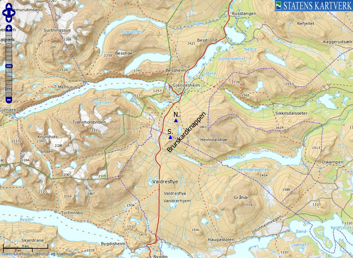
Søre and Nordre Brurskardknappen are two independent tops that are part of the greater Heimdalshøe (1843m) massif. Both tops are easy walks from highway RV51 on Valdresflya. This page will describe a path up to Søre Brurskardknappen. From the top, you have a fairly good view towards the eastern Jotunheimen mountain range;

Eastern Jotunheimen 2000m peaks
(Click for larger image)
The Vågå/Øystre Slidre border runs across the top of S. Brurskardknappen, while the north top fully belongs to Vågå. If you are in luck, you may get a glimpse of the Valdresflya reindeer herd. Follow the trip report link on the bottom of the page for pictures.

Reindeer on S. Brurskardknappen
(Click for larger image)
S. Brurskardknappen (Norge 1:50,000: 1458m, Økonomisk Kartverk: -, UTM 32 V 490704 6812295) has a primary factor of 148m towards the higher parent N. Brurskardknappen (1464m) The defining saddle (approx. 32 V 491288 6812917) is found just west of Brurskardstjønne. Ref. Norge 1:50,000 (20m contours), the saddle is within the range 1300-1320m, interpolated to 1310m.

N. Brurskardknappen
(Click for larger image)
Google's interactive map. You can zoom, pan and click on the markers.
|
|
|
|
Route 1: Valdresflya - S. Brurskardknappen (spring/summer/autumn)
|
|
This route description is valid per Apr 2011
Access
(all distances are approx. distances)
The starting point for this route description is Valdresflya along highway RV51. This road is not open during winter and opens around Easter time. Check vegvesen.no for details. Locate Heimdalsmunnen (1170m - N61.43077 E8.80487) southwest of S. Brurskardknappen and find parking there.
The route
From the parking, locate the Oskampen/Bygdin/Gjendesheim signpost and follow the path in the direction of the southwest ridge. The path is vague here and there, but once you get on the ridge, the route to the top is obvious. There are no difficult sections and this is a nice family hike.

The route to S. Brurskardknappen
(Click for larger image)
|
|


